


Verdun, France – February 1916 Salient Operational Map
Verdun, France – February 1916 Salient Operational Map
The Battle of Verdun stands as one of the most catastrophic engagements in the history of modern warfare. Fought along the Meuse River north of the French fortress city of Verdun from February through December 1916, the battle consumed over 300,000 lives across 303 days of continuous attritional combat. Germany's strategic objective was not merely territorial conquest but the deliberate hemorrhaging of French manpower—an industrial-scale attempt to bleed the French Army to the point of collapse. France's resolute defense transformed Verdun into a national symbol of sacrifice and endurance that defined an entire generation.
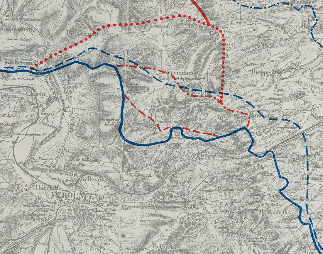
Historical Context On February 21, 1916, the German Fifth Army under Crown Prince Wilhelm launched Operation Gericht with one of the heaviest artillery bombardments in history, advancing rapidly through the French forward positions toward the key fortifications at Douaumont and Vaux. This map captures the entire arc of that struggle—from the original French line on 21 February through the successive German advances of March and July, and then the methodical French counteroffensives of July through December 1916 that ultimately restored much of the lost ground. The final line depicted, from the French advance of August–September 1917, reflects follow-on operations in the same salient conducted after the formal conclusion of the battle. The chronological layering of these front lines makes this map an unparalleled operational record of how the salient contracted, deepened, and was gradually reclaimed.
The Map's Features Rendered at a scale of 1:80,000 and published by the British General Staff in 1917, this English-language operational map overlays seven distinct phase lines atop a detailed topographical base of the Verdun region, tracing the full ebb and flow of the salient from its opening German advance to the closing French recovery operations. Blue dash-and-dot lines mark the original French defensive positions and subsequent German gains, while red dashed and dotted lines delineate the successive stages of the French counteroffensive across the Meuse heights. The underlying terrain—ridgelines, villages, roads, and river courses—provides the essential geographic context for understanding why each incremental advance or withdrawal carried such enormous tactical consequence. A comprehensive legend precisely identifies each dated phase line, allowing the viewer to reconstruct the operational chronology with clarity.
Historical Significance Verdun fundamentally shaped the strategic conduct of the First World War and the psychological identity of France for decades to come. The battle's inconclusive attritional logic—staggering casualties absorbed in exchange for negligible territorial gain—became the defining symbol of industrial-age warfare's human cost. The French counteroffensives of October and December 1916, which recovered Forts Douaumont and Vaux, demonstrated that German gains were neither permanent nor decisive, and that French operational resolve had not broken. This map preserves that entire arc of struggle in a single document, serving as a primary cartographic record of one of history's most consequential battles.
Museum-Quality Reproduction This is a high-quality reproduction of the original historic map, professionally printed on archival Hahnemühle paper using the Giclée printing process to preserve fine cartographic detail, line clarity, and period authenticity for long-term display.
Perfect For:
- Military historians and students of the First World War
- Collectors of Western Front and Great War cartography
- Veterans and families with ancestral connections to the French or Allied forces
- Offices, libraries, and institutional heritage displays
- Gifts honoring French military history and the centenary of the Great War
Specifications:
- Original Publication: 1917
- Style: Operational salient phase-line map
- Battle/Conflict: Battle of Verdun (World War I)
- Battle Result: French Victory
- Product Type: High-Quality Reproduction Print
- Scale: 1:80,000
Dimensions (Width x Height): 24.4 x 17.8
Each map is printed using the finest materials and methods. Your map will be handled with white gloves from start to finish. We use the Giclée printing method on Hahnemühle paper, which produces a clear, extremely detailed, durable map perfect for proud display in your home or office.
Choose options
