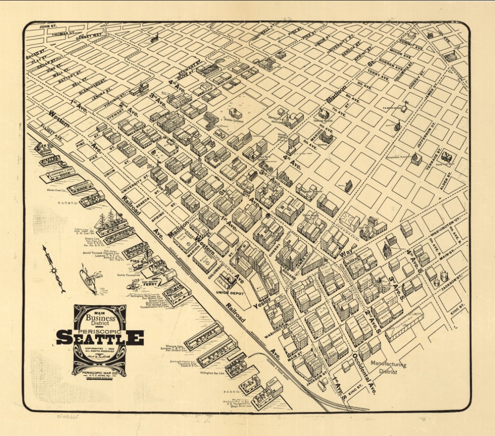

Seattle, Washington – 1903 Bird’s Eye View Map
Seattle, Washington – 1903 Bird’s Eye View Map
Experience Seattle at a defining moment in its transformation with this detailed 1903 bird’s-eye view map capturing the city as it surged into prominence as a major Pacific Northwest port. Viewed from an elevated perspective, the map reveals the dense street grid, bustling waterfront, rail yards, docks, and industrial corridors that anchored Seattle’s rapid growth at the dawn of the 20th century. Elliott Bay, the working harbor, and the expanding downtown core are rendered with remarkable clarity, offering an immediate sense of a city built on trade, industry, and connection to the sea.
Historical Context
By 1903, Seattle had emerged from the ashes of the Great Seattle Fire of 1889 and rebuilt itself into a modern, resilient city. Fueled by the Klondike Gold Rush at the turn of the century, Seattle became the primary outfitting and departure point for prospectors heading north, injecting capital, population, and ambition into the city. Rail connections tied Seattle to the interior, while its deep-water harbor positioned it as a critical gateway to Alaska and the Pacific world. This map reflects that moment of confidence and expansion, when Seattle was no longer a frontier town but a rising commercial powerhouse.
The Map’s Features
This richly illustrated bird’s-eye view showcases Seattle’s urban form and economic engine, including the organized downtown street grid, prominent rail lines and terminals, extensive waterfront piers and shipping activity along Elliott Bay, residential neighborhoods climbing the city’s hills, industrial districts marked by factories and warehouses, and surrounding waterways that defined Seattle’s geography and growth. The elevated perspective emphasizes how rail, port, and city were physically and economically intertwined.
Historical Significance
This 1903 view captures Seattle in the midst of its early boom years, just as it solidified its identity as the Pacific Northwest’s dominant city. It documents the post-fire rebuild, the lasting impact of the Gold Rush, and the infrastructure that would support Seattle’s evolution into a global port city. For residents, historians, and collectors, the map offers a powerful visual connection to a formative era when the foundations of modern Seattle were firmly laid.
Museum-Quality Reproduction
This is a high-quality reproduction of the original 1903 bird’s-eye view, professionally printed using museum-grade methods and materials. Each map is produced on archival Hahnemühle paper using the Giclée printing process, ensuring exceptional detail, durability, and a refined finish suitable for prominent display in a home, office, or study.
Perfect For:
• Seattle residents and those with personal ties to the city
• Pacific Northwest and urban history enthusiasts
• Collectors of bird’s-eye view and city maps
• Offices, libraries, and study spaces
• Gifts celebrating Seattle heritage and identity
Specifications:
• Original Publication: 1903
• Style: Bird’s-eye panoramic city view
• Historical Context: Post-Great Fire rebuild and Gold Rush–era expansion
• Product Type: High-Quality Reproduction Print
Dimensions (Width x Height): 27 x 23.8
Each map is printed using the finest materials and methods. Your map will be handled with white gloves from start to finish. We use the Giclée printing method on Hahnemühle paper, which produces a clear, extremely detailed, durable map perfect for proud display in your home or office. Digital watermark does not appear on your purchased map.
Choose options
