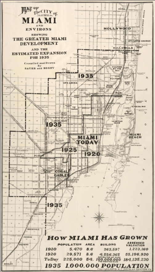

Miami, Florida – 1935 Growth and Expansion Map
Miami, Florida – 1935 Growth and Expansion Map
Experience Miami at a pivotal moment in its transformation with this striking 1935 map illustrating the city’s rapid growth, development, and projected expansion. Created during the height of South Florida’s early boom era, this map documents how Miami evolved from a small coastal settlement into a sprawling metropolitan center, tracing population growth, transportation corridors, and newly developed neighborhoods across the region.
Historical Context
By the early 20th century, Miami was one of America’s fastest-growing cities, driven by rail access, real estate speculation, tourism, and its strategic coastal location. This 1935 map captures Miami as it emerged from its early boom-and-bust cycles and positioned itself for long-term growth, highlighting development phases from 1910 through the 1930s. It reflects a moment when planners, investors, and residents alike believed Miami’s expansion was only beginning.
The Map’s Features
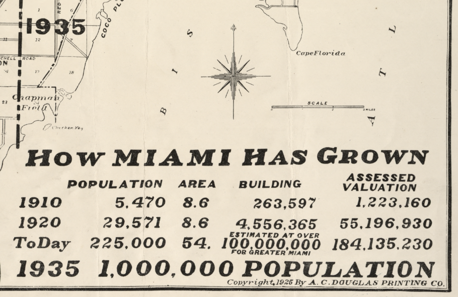
This detailed urban planning map presents Miami and its surrounding communities with clear emphasis on growth patterns, showing city boundaries at different points in time, major roadways and rail lines, coastal geography, and the expanding footprint of neighborhoods such as Miami Beach, Coral Gables, and surrounding suburbs. Population figures and projected expansion zones reveal how dramatically the city had grown in just a few decades.
Historical Significance
More than a street map, this piece serves as a visual record of Miami’s ambition and identity during the early 20th century. It documents the city’s transformation into a major American urban center and offers modern viewers a powerful point of connection to Miami’s past—ideal for those who have lived, worked, or served in South Florida and want to see how the region took shape.
Museum-Quality Reproduction
This is a high-quality reproduction of the original 1935 map, professionally printed using museum-grade methods to preserve every line, label, and detail. Each print is produced on archival Hahnemühle paper using the Giclée printing process, ensuring exceptional clarity, durability, and a refined finish suitable for long-term display.
Perfect For:
• Miami residents and South Florida natives
• Urban history and city planning enthusiasts
• Real estate, architecture, and development professionals
• Offices, libraries, and home displays
• Gifts for those with a deep connection to Miami
Specifications:
• Original Publication: 1935
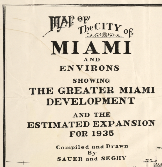
• Title: Map of the City of Miami and Environs Showing the Greater Miami Development and the Estimated Expansion for 1935
• Cartographer: Sauer & Seghy
• Style: Early 20th-century urban planning map
• Product Type: High-Quality Reproduction Print
Dimensions (Width x Height): 12.4 x 21.7
Each map is printed using the finest materials and methods. Your map will be handled with white gloves from start to finish. We use the Giclée printing method on Hahnemühle paper, which produces a clear, extremely detailed, durable map perfect for proud display in your home or office.
Digital watermark does not appear on your purchased map.
Choose options
