


Fort McHenry, Baltimore, Maryland – 1857 Panoramic Drawing
Fort McHenry, Baltimore, Maryland – 1857 Panoramic Drawing
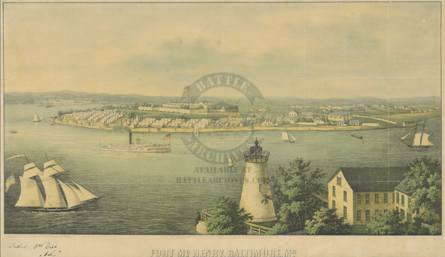
Standing at the mouth of the Patapsco River where it opens into the Chesapeake Bay, Fort McHenry is one of the most symbolically significant military installations in American history — the fortification whose garrison held against a sustained British naval bombardment in September 1814 and inspired the words that became the national anthem of the United States. This 1857 panoramic drawing presents Fort McHenry and its surrounding harbor in the decades following that famous engagement, capturing the star-shaped fortification, the lighthouse at Whetstone Point, and the busy maritime commerce of Baltimore's waterfront in the mid-nineteenth century.
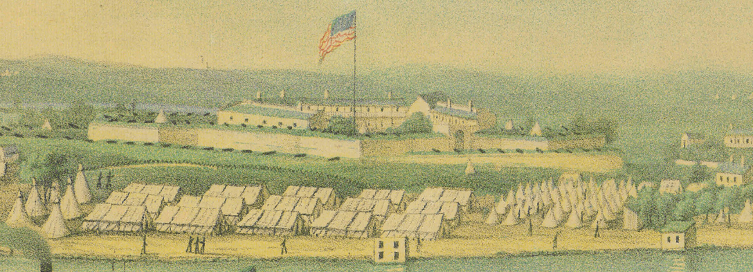
Historical Context Completed in 1798 and named for Secretary of War James McHenry, the fort was designed specifically to defend Baltimore from naval assault by controlling the deep-water approach up the Chesapeake Bay. That strategic purpose was tested on September 13–14, 1814, when a Royal Navy squadron of nineteen vessels — including bomb ketches and a rocket ship — unleashed a 25-hour bombardment against the fort's garrison of approximately 1,000 American defenders under Major George Armistead. The British sustained enough damage during a preliminary ground assault to abandon plans for a land attack, and when the garrison's 30-by-42-foot garrison flag remained flying over the fort at dawn on September 14th, Maryland lawyer Francis Scott Key — watching from a truce vessel in the harbor — composed the verses that would become "The Star-Spangled Banner." This 1857 illustration was produced more than four decades after that engagement, documenting the fort as it appeared in peacetime — a sentinel still standing watch over the harbor it had defended.
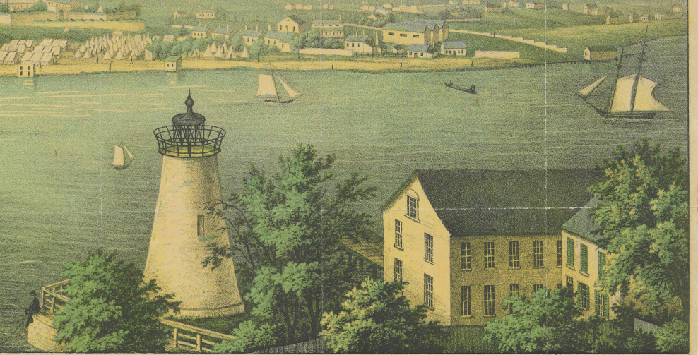
The Map's Features This panoramic illustration renders Fort McHenry and its harbor setting with the detailed, atmospheric quality characteristic of mid-nineteenth century American lithographic art. The star-shaped earthwork fortification with its interior barracks and parade ground is depicted from an elevated perspective looking north across the Patapsco River toward Baltimore. The Whetstone Point lighthouse anchors the foreground, while a variety of period watercraft — tall-masted sailing vessels, a sidewheel steam packet, and smaller harbor boats — animate the surrounding waters. The rolling Maryland shoreline and distant city buildings extend across the background, situating the fort within the broader geography of one of America's most important antebellum ports.
Historical Significance Fort McHenry's successful defense in September 1814 secured Baltimore from British occupation and provided the young American republic with one of its most enduring symbols of national resilience. The national anthem born from that night's bombardment transformed the fort from a military installation into a cultural monument. Designated a National Monument and Historic Shrine in 1925 — the only site in the United States to hold that dual designation — Fort McHenry continues to stand as physical proof that the flag was still there. A mid-century panoramic illustration of this site is both a work of historical documentation and an artifact of American national identity.
Framing Options This map is available unframed or professionally framed and ready to hang. Choose from a classic Black Frame or a warm Walnut Brown Frame, each matted with 4-ply white archival mat board and finished with non-glare acrylic glazing for a clean, museum-style presentation. Framed orders are professionally assembled and shipped directly to your door. Please allow 3–4 weeks for delivery on framed orders.
Museum-Quality Reproduction This is a high-quality reproduction of the original 1857 panoramic illustration, professionally printed on archival Hahnemühle paper using the Giclée printing process to preserve fine artistic detail, tonal range, and period authenticity for long-term display.
Perfect For:
- American history collectors and War of 1812 enthusiasts
- Veterans, military families, and those with a connection to Maryland and Baltimore
- Admirers of the national anthem and American patriotic heritage
- Home offices, libraries, and heritage display settings
- Gifts for history lovers with ties to the Chesapeake region
Specifications:
- Original Publication: 1857
- Scale: Unknown
- Style: Panoramic harbor illustration
- Battle/Conflict: Defense of Baltimore, War of 1812
- Battle Result: American Victory
- Product Type: High-Quality Reproduction Print
Dimensions (Width x Height): 17 x 10
Each map is printed using the finest materials and methods. Your map will be handled with white gloves from start to finish. We use the Giclée printing method on Hahnemühle paper, which produces a clear, extremely detailed, durable map perfect for proud display in your home or office.
Choose options
