

Dallas County, Texas – Official County Map
Dallas County, Texas – Official County Map
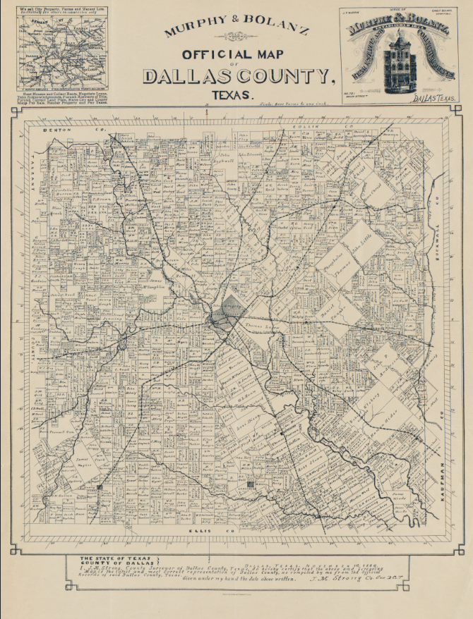
Experience Dallas at a formative moment in its transformation from frontier crossroads to regional center with this detailed official map of Dallas County. Rendered with meticulous precision, the map captures the county’s road networks, property divisions, rail lines, waterways, and the early urban footprint of Dallas at the heart of North Texas, offering a rare look at how the region was organized as growth accelerated outward from the city core.
Historical Context
Produced during a period when Dallas was rapidly asserting itself as a commercial and transportation hub, this county map reflects the forces that shaped modern North Texas. Railroads radiating from Dallas illustrate the city’s emerging role as a regional nexus, while surrounding farms, towns, and land parcels reveal a landscape still closely tied to agriculture and rural settlement. For residents and descendants alike, this map preserves the moment when Dallas County was being actively defined, surveyed, and connected.
The Map’s Features
This official county map presents Dallas County in exceptional detail, showing property boundaries, landowner names, township divisions, creeks and rivers, wagon roads, and expanding rail infrastructure. Insets and decorative elements reinforce its use as both a practical reference and a statement of civic confidence, while the dense labeling highlights how thoroughly the county had been surveyed and organized.
Historical Significance
As an official county map, this piece documents the structural foundation of Dallas’s growth. It illustrates how transportation corridors, land ownership, and early planning set the stage for Dallas’s rise into one of America’s major metropolitan areas. For those with roots in North Texas, it offers a powerful way to locate family land, neighborhoods, and routes that shaped daily life generations ago.
Museum-Quality Reproduction
This is a high-quality reproduction of the original Dallas County map, professionally printed using museum-grade methods and materials to preserve every line and annotation. Each map is produced on archival paper using the Giclée printing process, ensuring exceptional clarity, durability, and a refined finish suitable for display in any home or office.
Perfect For:
• Dallas and North Texas residents with deep local ties
• Genealogists researching land and family history
• Collectors of Texas and American county maps
• Offices, libraries, and study spaces
• Meaningful gifts for lifelong Dallas locals
Specifications:
• Created / Published: Late 19th century
• Cartographer: Murphy & Bolanz
• Style: Official county reference map
• Product Type: High-quality reproduction print
Dimensions (Width x Height): 22.8 x 30
Each map is printed using the finest materials and methods. Your map will be handled with white gloves from start to finish. We use the Giclée printing method on archival paper, producing a clear, extremely detailed, durable map perfect for proud display in your home or office. Digital watermark does not appear on your purchased map.
Choose options
