


Cincinnati, Ohio – 1838 City Map
Cincinnati, Ohio – 1838 City Map
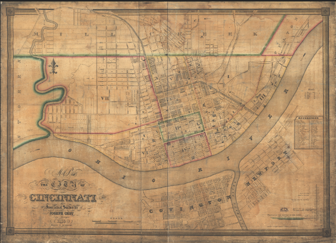
This detailed 1838 map of Cincinnati captures the city during its rapid rise as one of the most important urban centers in the American interior. Oriented along the broad curve of the Ohio River, the map presents a growing but still compact street grid, clearly defined wards, and expanding neighborhoods that reflect Cincinnati’s transformation from frontier town to regional powerhouse. The riverfront dominates the layout, emphasizing the city’s dependence on river commerce and its strategic position connecting eastern markets to the western frontier.
Historical Context In 1838, Cincinnati was emerging as the leading city of the Ohio Valley and one of the fastest-growing cities in the United States. River trade, steamboat traffic, manufacturing, and meatpacking fueled its expansion, while waves of immigration—particularly from German communities—shaped its culture and economy. This period marked Cincinnati’s ascent toward its mid-19th-century peak, before railroads and industrialization further accelerated its growth.
The Map’s Features This city map shows Cincinnati’s early downtown core clustered along the Ohio River, an orderly grid of streets extending inland, and clearly delineated wards and property divisions. Wharves, ferry crossings, and riverfront infrastructure highlight the city’s commercial lifeline, while decorative cartouches and hand-applied color reflect the craftsmanship typical of early American urban maps.
Historical Significance The map preserves Cincinnati at a formative stage in its development, documenting the city just as it was earning its reputation as the “Queen City of the West.” It offers valuable insight into early urban planning, governance, and transportation patterns in one of America’s most influential pre–Civil War cities.
Museum-Quality Reproduction This is a high-quality reproduction of the original 1838 Cincinnati city map, professionally printed on archival Hahnemühle paper using the Giclée printing process to preserve fine linework, subtle coloring, and period detail for long-term display.
Perfect For:
• Cincinnati residents and Ohio history enthusiasts
• Collectors of early American city maps
• Urban history and river commerce historians
• Offices, libraries, and study spaces
• Gifts celebrating Cincinnati’s early growth
Specifications:
• Map Type: Early 19th-century city plan
• Created/Published: 1838
• Style: Hand-colored engraved city map
• Historical Context: Cincinnati’s rise as a major Ohio River trade center
• Product Type: High-Quality Reproduction Print
Dimensions (Width x Height): 27.3 x 19.7
Each map is printed using the finest materials and methods. Your map will be handled with white gloves from start to finish. We use the Giclée printing method on Hahnemühle paper, which produces a clear, extremely detailed, durable map perfect for proud display in your home or office.
Digital watermark does not appear on your purchased map.
Choose options
