


Charlestown, Massachusetts – June 17, 1775 Battle Map
Charlestown, Massachusetts – June 17, 1775 Battle Map
On June 17, 1775, less than two months after the first shots of the American Revolution were fired at Lexington and Concord, colonial militiamen and British regulars met in the first major pitched battle of the war on the hills north of Boston overlooking Charlestown. What the colonists lacked in training and supply, they demonstrated in resolve — holding their positions against two full British assaults before being driven from the heights on the third. The battle settled nothing strategically, but it proved something that neither side had yet established: that American fighting men would stand in the open against the finest professional army in the world, extract a punishing price, and force the British to reconsider the cost of suppressing this rebellion.
Historical Context Following the engagements at Lexington and Concord in April 1775, colonial forces besieged the British garrison in Boston. In mid-June, American commanders learned that British General Thomas Gage intended to occupy the high ground surrounding the city to break the siege. On the night of June 16, Colonel William Prescott led roughly 1,200 colonial troops onto the Charlestown peninsula and constructed field fortifications through the night. Though the primary objective had been Bunker Hill, most of the defensive works were erected on the lower adjacent rise — unnamed at the time and known to history as Breed's Hill only after the battle had been fought. On the morning of June 17, British forces under Major General William Howe landed on the peninsula and advanced uphill against entrenched defenders. Two assaults were repulsed with severe British casualties before a third, mounted after American ammunition was exhausted, carried the position.
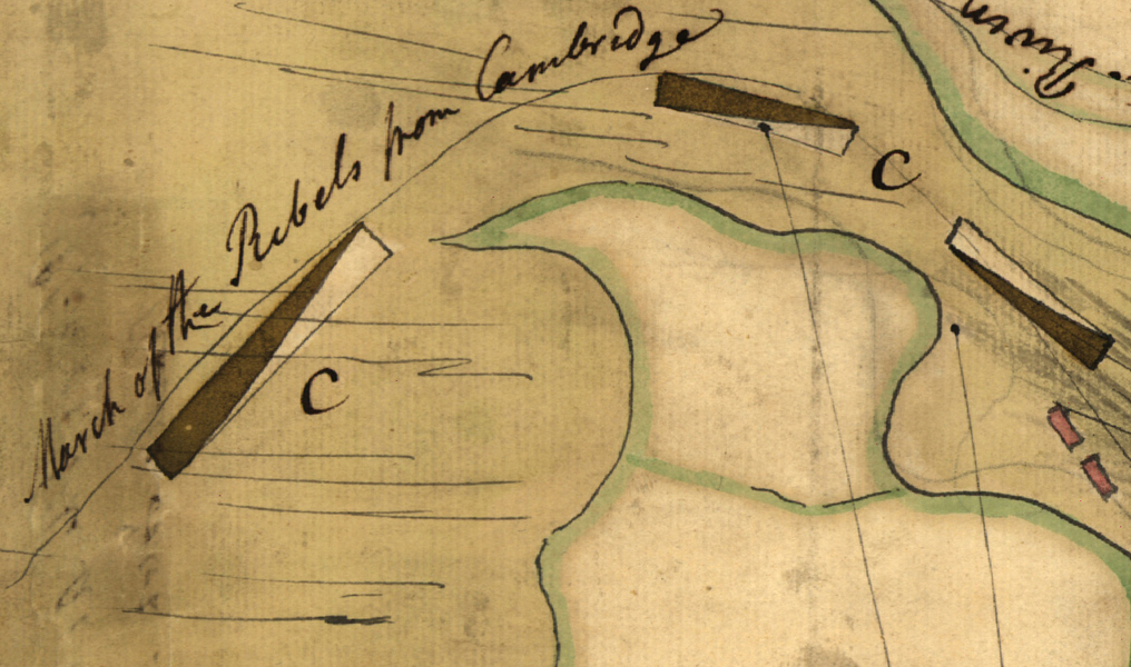
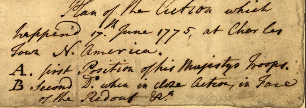
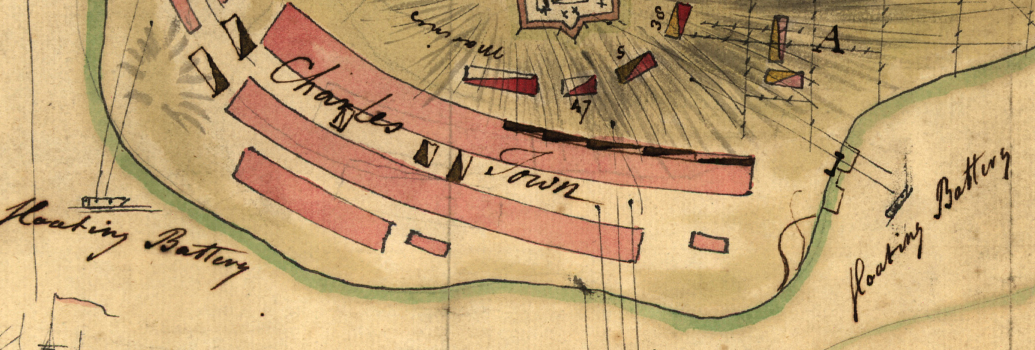
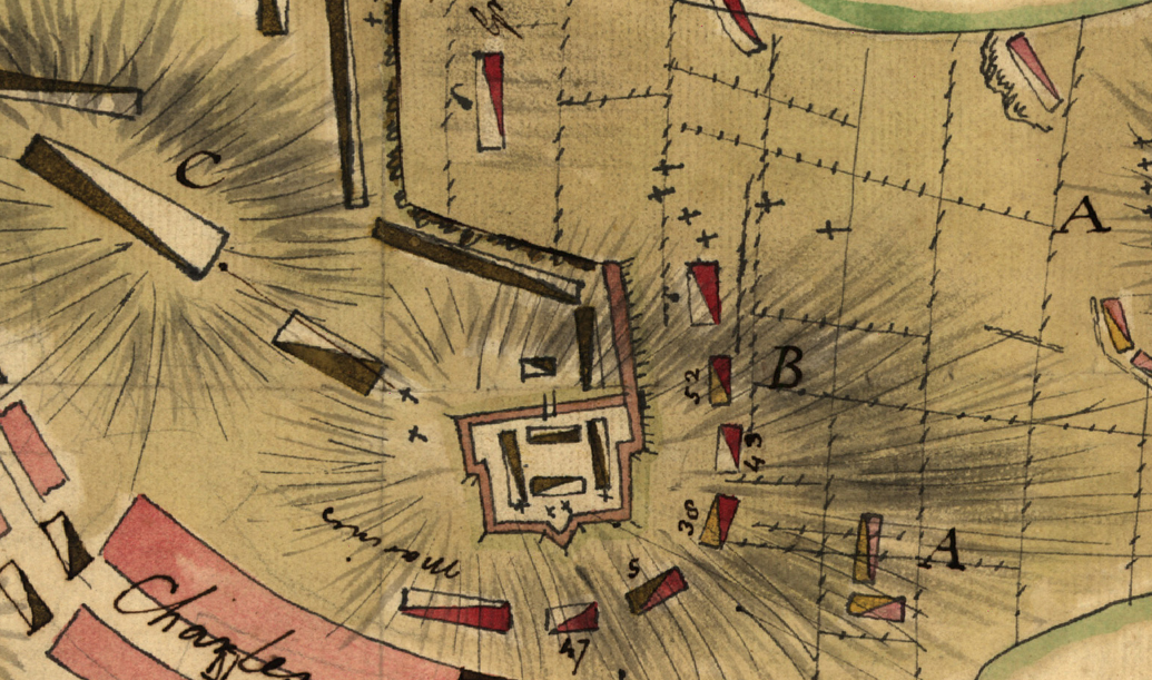
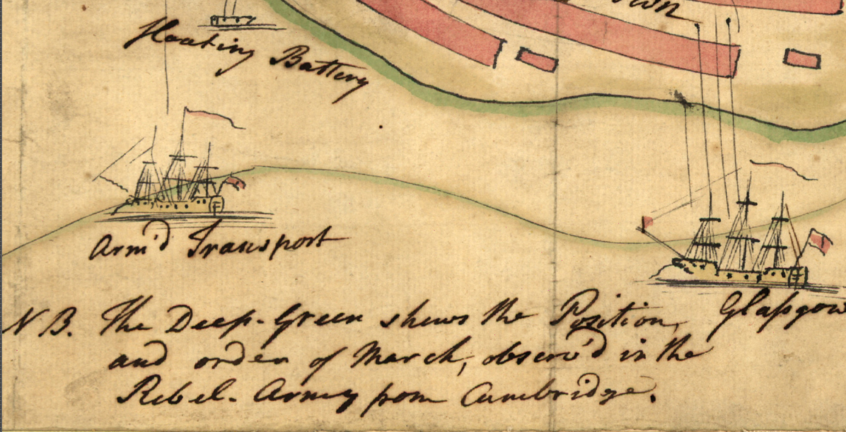
The Map's Features This hand-drawn color map, titled in period script "Plan of the Action which Happened on 17th June 1775," documents the engagement as it was understood by a participant or near-contemporary observer in the immediate aftermath of the battle. American and British unit positions are rendered across all three hills of the Charlestown peninsula — Bunker Hill, Breed's Hill, and the ground between — using color-coded unit symbols that distinguish colonial and Crown forces. The march of American forces from Cambridge is annotated along the approach routes. Flanking batteries, naval transport positions, and the town of Charlestown itself are marked, providing a complete operational picture of the terrain and dispositions. The accompanying notation identifies the deep green markings as showing the position and order of march of the rebel force from Cambridge, and distinguishes His Majesty's Troops in first position from their second position in close action before the redoubt — a level of specificity that reflects direct observation or immediate firsthand accounts.
Historical Significance The Battle of Bunker Hill demonstrated that the American rebellion possessed both the organizational capacity to construct field fortifications under pressure and the tactical discipline to hold them against repeated frontal assault. British casualties — over 1,000 killed and wounded out of roughly 2,400 engaged — shocked London and permanently altered British strategic assumptions about the cost of suppressing the colonial uprising. For the Continental cause, the engagement provided early proof that the revolution had committed, capable fighters behind it. This hand-drawn map, produced in 1775, is among the rarest category of American Revolutionary cartography: a period document created at or within living memory of the event it depicts, drawn before the outcome of the revolution itself was known.
Framing Options This map is available unframed or professionally framed and ready to hang. Our framing partner uses museum-quality materials to protect and present your print for long-term display. Choose from a classic Black frame or a warm Walnut Brown frame — both available with your order. Please allow 3–4 weeks for delivery on framed orders.
Museum-Quality Reproduction This is a high-quality reproduction of the original historic map, professionally printed on archival Hahnemühle paper using the Giclée printing process to preserve fine cartographic detail, line clarity, and period authenticity for long-term display.
Perfect For:
- American Revolution historians and collectors of early American military cartography
- Descendants of colonial militiamen or British regulars who served in the Boston campaign
- Students and educators of Revolutionary War history and early American military tactics
- Offices, studies, libraries, and heritage displays honoring the founding era
- Gifts for history enthusiasts with New England or American patriot heritage
Specifications:
- Original Publication: 1775
- Scale: 1:8,000
- Style: Hand-drawn color operational battle map
- Battle/Conflict: Battle of Bunker Hill (American Revolutionary War)
- Battle Result: British Tactical Victory / American Strategic Victory (June 17, 1775)
- Product Type: High-Quality Reproduction Print
Dimensions (Width x Height): 15.1 x 9.6
Each map is printed using the finest materials and methods. Your map will be handled with white gloves from start to finish. We use the Giclée printing method on Hahnemühle paper, which produces a clear, extremely detailed, durable map perfect for proud display in your home or office.
Choose options
