Nashville, Tennessee – 1897 Tennessee Centennial Exposition Bird’s-Eye View Map
Nashville, Tennessee – 1897 Tennessee Centennial Exposition Bird’s-Eye View Map
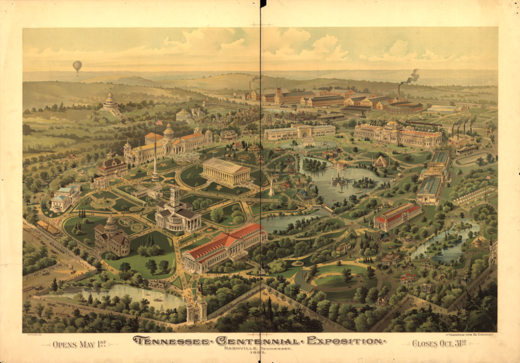
Step into Nashville at the height of its Gilded Age ambition with this richly illustrated bird’s-eye view of the Tennessee Centennial Exposition. Created in advance of the 1897 opening, this vibrant panoramic map presents the fairgrounds as a grand, carefully planned landscape of monumental buildings, formal gardens, lagoons, and walkways set against the rolling hills outside the city. The scene captures Nashville presenting itself to the nation as a modern, cultured Southern city at the dawn of a new century.
Historical Context
The Tennessee Centennial and International Exposition was held to celebrate the 100th anniversary of Tennessee’s admission to the Union. Opening on May 1, 1897, and closing October 31, the exposition showcased industrial progress, art, agriculture, and education while signaling Nashville’s growing regional importance. Often called the “Athens of the South,” Nashville used the exposition to reinforce its cultural identity, an ambition still symbolized today by the full-scale Parthenon replica constructed for the event. This map preserves the exposition as it was envisioned before opening, reflecting both optimism and civic pride.
The Map’s Features
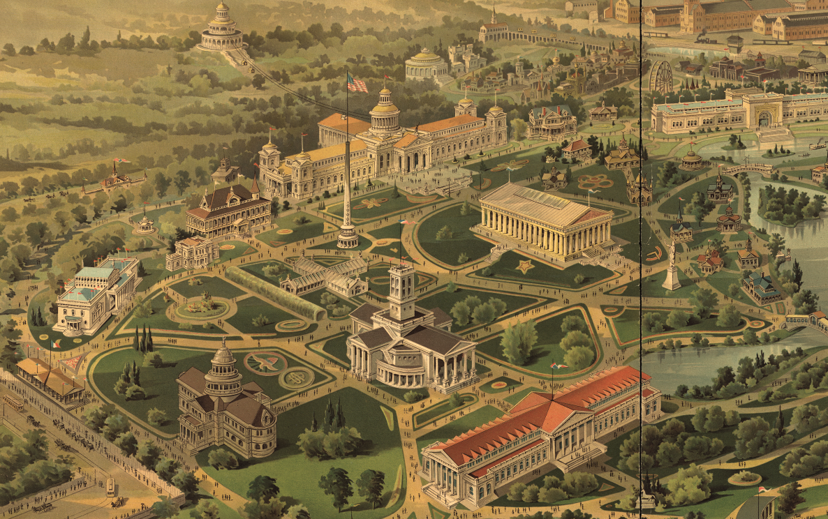
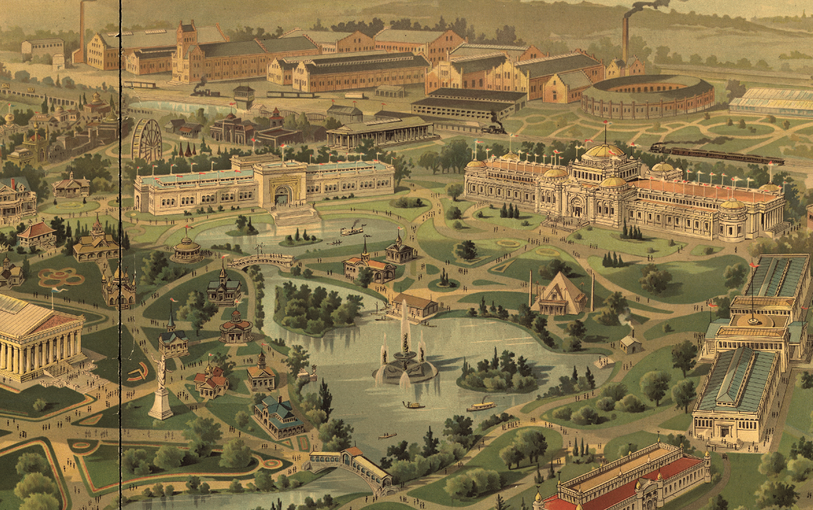
This bird’s-eye view illustrates the full exposition grounds in perspective, including the Parthenon, exhibition halls, formal plazas, landscaped lakes, and radiating paths that organized visitor movement. Architectural symmetry, ornamental landscaping, and surrounding countryside are emphasized, while banners announcing the opening and closing dates reinforce the temporary but monumental nature of the event. The map is not drawn to scale, prioritizing visual clarity and grandeur over precise measurement.
Historical Significance
The map documents one of the most important cultural events in Nashville’s history. It provides a visual record of how the city sought to define itself at the end of the 19th century—forward-looking, refined, and nationally relevant. For historians and collectors, it stands as a lasting artifact of the exposition era and Nashville’s transformation from regional center to nationally recognized city.
Museum-Quality Reproduction
This is a high-quality reproduction of the original 1897 bird’s-eye view, professionally printed on archival Hahnemühle paper using the Giclée printing process to preserve color, detail, and period character for long-term display.
Perfect For:
• Nashville residents and Tennessee natives
• Collectors of exposition and world’s fair maps
• Architectural and urban history enthusiasts
• Offices, libraries, and study spaces
• Gifts celebrating Nashville’s cultural heritage
Specifications:
• Original Publication: 1896
• Publisher: The Henderson Litho. Co., Cincinnati
• Style: Hand-colored bird’s-eye perspective exposition map
• Product Type: High-Quality Reproduction Print
Dimensions (Width x Height): 27.8 x 19.4
Each map is printed using the finest materials and methods. Your map will be handled with white gloves from start to finish. We use the Giclée printing method on Hahnemühle paper, which produces a clear, extremely detailed, durable map perfect for proud display in your home or office.
Digital watermark does not appear on your purchased map.
Choose options
