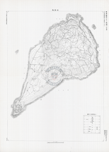
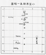
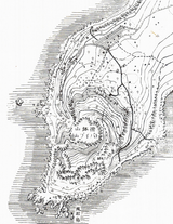
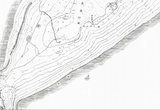


Iwo Jima, Japan – 1945 Japanese Defensive Positions Battle Map
Iwo Jima, Japan – 1945 Japanese Defensive Positions Battle Map
Examine the Battle of Iwo Jima from the Japanese perspective with this rare defensive positions map depicting how Imperial forces prepared the island for prolonged resistance. Unlike American planning and progress maps, this map reflects the defensive framework constructed to absorb invasion forces and inflict maximum casualties before the island fell.
Historical Context
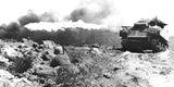
The Battle of Iwo Jima was fought from February 19 to March 26, 1945 in the Volcano Islands, approximately 750 miles south of Tokyo. Japanese planners transformed Iwo Jima into a fortified stronghold built around depth, concealment, and interlocking fields of fire. Rather than defending the beaches, Japanese forces relied on underground tunnels, reinforced positions, and interior strongpoints designed to survive bombardment and continue fighting long after initial landings.
The Map’s Features
This Japanese-produced map outlines defensive positions, internal routes, and terrain features across the island, providing insight into how the defense was organized beyond what Allied intelligence fully understood before the invasion. The cartographic emphasis reflects preparation for sustained resistance rather than maneuver warfare, highlighting the island-wide integration of fortifications rather than isolated strongpoints.
Historical Significance
Viewed alongside American assault plans and post-landing progress maps, this document reveals the strategic disconnect between Allied expectations and Japanese defensive doctrine. It helps explain why Marine advances stalled repeatedly and why Iwo Jima became one of the most costly battles in U.S. Marine Corps history, despite overwhelming naval and air superiority.
Museum-Quality Reproduction
This is a high-quality reproduction of the original World War II military map, professionally printed using museum-grade methods and materials to preserve every detail of this historic operational document. Each piece is produced on archival Hahnemühle paper using the Giclée printing process, ensuring exceptional clarity, durability, and a refined finish suitable for display in any setting.
Perfect For
• World War II and Pacific Theater historians
• U.S. Marine Corps veterans and families
• Iwo Jima campaign collectors
• Students of Japanese defensive doctrine
• Offices, libraries, and study spaces
• Displays honoring WWII service and sacrifice
Specifications
• Battle Result: American Victory
• Style: Mid-20th-century Japanese military defensive map
• Product Type: High-Quality Reproduction Print
• Dimensions (Width x Height): 19.7 x 27.6
Each map is printed using the finest materials and methods. Your map will be handled with white gloves from start to finish. We use the Giclée printing method on Hahnemühle paper, which produces a clear, extremely detailed, durable map perfect for proud display in your home or office.
Digital watermark does not appear on your purchased map


