


Iwo Jima, Japan – 1945 Assault First Day Situation Battle Map
Iwo Jima, Japan – 1945 Assault First Day Situation Battle Map
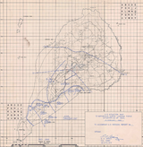
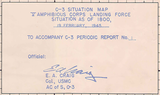
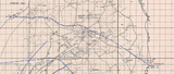
Capture the reality of the invasion’s opening hours with this detailed “C-3 Situation Map” showing the tactical situation on Iwo Jima as of 1800 hours on February 19, 1945—D-Day of the assault. This operational battle map documents what U.S. Marines had actually achieved by the end of the first day, revealing the hard-fought progress made under intense fire during one of the most difficult amphibious landings of World War II.
Historical Context
The Battle of Iwo Jima was fought from February 19 to March 26, 1945 in the Volcano Islands, approximately 750 miles south of Tokyo. U.S. Marine forces landed against deeply entrenched Japanese defenders who had constructed an extensive network of bunkers, tunnels, and fortified positions across the island. Although initial planning anticipated rapid inland advances, resistance proved far more severe than expected, particularly along the southern beaches and toward the island’s central airfields.
The Map’s Features
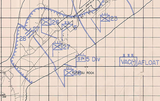
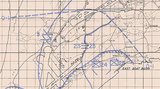
This first-day situation map shows Marine front lines and unit positions as they stood at 1800 on D-Day, tracing progress from the landing beaches inland toward the base of Mount Suribachi on the southern flank and northward toward Motoyama Airfield. Hand-drawn operational markings illustrate contested zones, stalled advances, and areas where Marines advanced only yards under relentless fire. The gridded layout and precise annotations reflect its use as a real-time command document rather than a postwar summary.
Historical Significance
Maps like this reveal the brutal truth of Iwo Jima’s opening day. Despite overwhelming naval and air support, Marine units faced devastating defensive fire that slowed progress to a crawl in many sectors. When compared with pre-invasion planning maps and later front-line progression charts, this document powerfully illustrates how reality diverged from expectations and why the battle would become one of the costliest in Marine Corps history.
Museum-Quality Reproduction
This is a high-quality reproduction of the original World War II military map, professionally printed using museum-grade methods and materials to preserve every detail of this historic operational document. Each piece is produced on archival Hahnemühle paper using the Giclée printing process, ensuring exceptional clarity, durability, and a refined finish suitable for display in any setting.
Perfect For
• World War II and Pacific Theater historians
• U.S. Marine Corps veterans and families
• Amphibious warfare and operational planning enthusiasts
• Military map and cartography collectors
• Offices, libraries, and study spaces
• Displays honoring WWII service and sacrifice
Specifications
• Battle Result: American Victory
• Created / Published: 1945
• Scale: 1:20,000
• Style: Mid-20th-century operational situation map
• Product Type: High-Quality Reproduction Print
• Dimensions (Width x Height): 19 x 19.5
Each map is printed using the finest materials and methods. Your map will be handled with white gloves from start to finish. We use the Giclée printing method on Hahnemühle paper, which produces a clear, extremely detailed, durable map perfect for proud display in your home or office.
Digital watermark does not appear on your purchased map.


