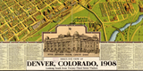


Denver, Colorado 1908 Bird's Eye View Map
Denver, Colorado - 1908 Bird's Eye View Map
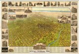
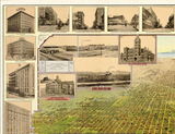
Step back to the dawn of the 20th century with this spectacular panoramic view of Denver, Colorado. Created in 1908, this sweeping perspective captures the Mile High City during a transformative era in American expansion and urban development.
A City at the Gateway to the West
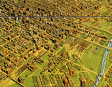
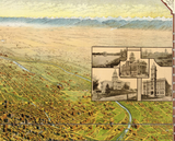
This meticulously detailed illustration showcases Denver's impressive street grid stretching toward the majestic Rocky Mountain foothills. Every building—from grand civic structures and commercial blocks downtown to residential neighborhoods sprawling across the plains—is rendered with remarkable precision. The map's comprehensive index highlights points of interest throughout the city, offering a window into Denver's landmarks, parks, and bustling districts as they appeared over a century ago.
Historical Significance
By 1908, Denver had evolved from a rough-and-tumble mining camp into Colorado's capital and the economic powerhouse of the Rocky Mountain region. This map captures that golden age of American optimism—the elegant Victorian architecture, emerging streetcar systems, and ambitious city planning that defined early 20th century urban America. As a strategic supply and transportation hub, Denver played a vital role in westward expansion and would later serve as a significant military logistics center during both World Wars.
Museum-Quality Reproduction
This is a high-quality reproduction of the original 1908 map, professionally printed using museum-grade methods and materials to preserve every detail of this historic cartographic treasure.
Perfect For:
- History enthusiasts and collectors of Americana
- Colorado natives and Denver transplants
- Anyone passionate about American city development
- Displaying alongside your military and historical collections
- Gift-giving for those who appreciate historical artifacts
Specifications:
- Original Publication: 1908
- Style: Perspective aerial view
- Features: Full-color illustration with indexed points of interest
- Product Type: High-Quality Reproduction Print
Dimensions (Width x Height): 20 x 13.8
Each map is printed using the finest materials and methods. Your map will be handled with white gloves from start to finish. We use the Giclee printing method on Hahnemuhle paper, which produces a clear, extremely detailed, durable map that is perfect to be proudly displayed in your home or office.
Digital watermark does not appear on your purchased map.


