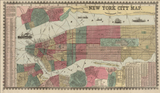


New York City - 1862 Map of Manhattan and Brooklyn
New York City - 1862 Map of Manhattan and Brooklyn
Experience New York at a pivotal moment in American history with this detailed 1862 map of Manhattan and surrounding cities. Published by James Miller during the height of the Civil War, this hand-colored street plan captures the nation's largest metropolis as it served as the Union's economic engine while grappling with internal divisions over the war effort.
A City at War
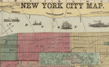
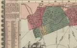
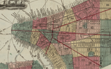
This meticulously detailed map showcases Manhattan south of 132nd Street, along with parts of Brooklyn, Jersey City, and Hoboken—revealing the interconnected urban landscape that formed America's greatest port and manufacturing center. The hand-colored ward boundaries illustrate the city's complex political geography, while radial distance markers from City Hall provide a geographic framework for understanding the expanding metropolis. Comprehensive street indexes for Manhattan, Brooklyn, and Williamsburg make this both a navigational tool and a historical document, while illustrations of ships and boats in the Hudson River emphasize the maritime commerce that drove the city's wealth and influence.
Historical Significance
1862 was a crucial year for New York and the nation. As the Civil War raged, the city simultaneously prospered from war contracts while confronting deep divisions over conscription and emancipation—tensions that would explode into the Draft Riots of 1863. This map captures New York at that fraught moment when it was transforming into a modern metropolis while struggling with its role in a nation torn apart. The detailed ward boundaries and street system document a city preparing for unprecedented growth, while the inclusion of Brooklyn (still an independent city) and New Jersey communities reflects the emerging regional economy that would define the modern New York metropolitan area.
Museum-Quality Reproduction
This is a high-quality reproduction of the original 1862 hand-colored map, professionally printed using museum-grade methods and materials to preserve every detail of this historic cartographic treasure.
Perfect For:
- History enthusiasts and collectors of Americana
- New York natives and Manhattan residents
- Anyone passionate about Civil War era history and urban development
- Displaying alongside your military and historical collections
- Gift-giving for those who appreciate historical artifacts
Specifications:
- Original Publication: 1862
- Style: Street plan with hand-colored ward boundaries
- Features: Radial distance markers from City Hall, street indexes, Hudson River maritime illustrations
- Product Type: High-Quality Reproduction Print
Dimensions 20 x 11.6
Each map is printed using the finest materials and methods. Your map will be handled with white gloves from start to finish. We use the Giclee printing method on Hahnemuhle paper, which produces a clear, extremely detailed, durable map that is perfect to be proudly displayed in your home or office.
Digital watermark does not appear on your purchased map.


