


Denver, Colorado - 1881 Bird's Eye View Map
Denver, Colorado - 1881 Bird's Eye View Map
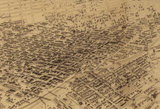
Experience Denver during its explosive growth as a frontier boomtown with this remarkable panoramic view from 1881. Created by J.H. Flett, this sweeping perspective captures the young city just two decades after its founding, revealing the raw ambition and rapid expansion that defined the American West.
From Mining Camp to Mountain Metropolis
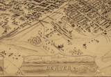
This meticulously detailed illustration showcases Denver's early street grid spreading across the plains, with the majestic Rocky Mountains rising dramatically in the background. Every structure—from wooden storefronts and early municipal buildings to residential blocks pushing toward the city's edges—tells the story of a community transforming almost overnight from a gold rush camp into a permanent settlement. The map includes compelling illustrations and a historical view of Denver from 1859, offering a powerful visual comparison of the city's remarkable 22-year transformation.
Historical Significance
By 1881, Denver stood at a crucial turning point. The silver boom was in full swing, transcontinental railroads had arrived, and the city was cementing its position as the supply hub for Colorado's mining districts. This map captures that pivotal moment—when frontier roughness still mixed with emerging Victorian refinement, and when fortunes were being made and lost overnight. Within a decade, Denver would become a modern American city, making this 1881 view an invaluable record of its last years as a true frontier town.
Museum-Quality Reproduction
This is a high-quality reproduction of the original 1881 map, professionally printed using museum-grade methods and materials to preserve every detail of this historic cartographic treasure.
Perfect For:
- History enthusiasts and collectors of Americana
- Colorado natives and Denver transplants
- Anyone passionate about Western expansion and frontier history
- Displaying alongside your military and historical collections
- Gift-giving for those who appreciate historical artifacts
Specifications:
- Original Publication: 1881
- Style: Perspective aerial view
- Features: Full-color illustration with views of Denver from 1859 and 1881
- Product Type: High-Quality Reproduction Print
Dimensions (Width x Height): 20 x 13.1
Each map is printed using the finest materials and methods. Your map will be handled with white gloves from start to finish. We use the Giclee printing method on Hahnemuhle paper, which produces a clear, extremely detailed, durable map that is perfect to be proudly displayed in your home or office.
Digital watermark does not appear on your purchased map.


