


New York City - 1660 New Amsterdam Colonial Map
New York City - 1660 New Amsterdam Colonial Map
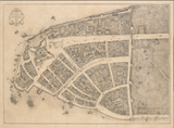
Step back to the very beginning of New York with this extraordinary map of New Amsterdam in 1660—a detailed view of the Dutch colonial settlement that would become America's greatest city. This redraft of the historic Castello Plan captures the compact community at the southern tip of Manhattan when it was home to fewer than 1,500 European settlers under Dutch rule, just four years before the English would seize control and rename it New York.
The Dutch Colonial Settlement
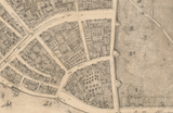
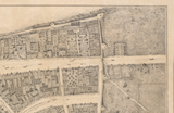
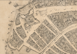
This meticulously detailed map showcases New Amsterdam's fortified layout along the East River and Hudson River waterfronts. Every building, street, and defensive structure reveals the careful planning of a frontier trading post designed to control the lucrative fur trade with Native American nations. The famous wall along present-day Wall Street, the windmill, the fort, the canal, and the early church all appear in their original positions, documenting the architectural and urban landscape that would be transformed beyond recognition in the coming centuries. Individual structures are identified, offering an intimate portrait of daily life in this Dutch outpost on the edge of the known world.
Historical Significance
In 1660, New Amsterdam stood as the capital of New Netherland, a thriving commercial hub where Dutch, English, French, and African residents lived and traded alongside the indigenous Lenape people. This map captures that multicultural moment before English conquest would reshape the colony's identity. The street pattern, building locations, and defensive works shown here represent the foundation upon which modern New York would eventually rise. This is the genesis of Wall Street, Broadway, and the grid that would define Manhattan—visible here in its earliest, humblest form. Within just a few years, the Dutch would surrender to the English, making this snapshot of New Amsterdam under the Dutch flag especially poignant and historically significant.
Museum-Quality Reproduction
This is a high-quality reproduction of the 1916 redraft of the original 1660 Castello Plan, professionally printed using museum-grade methods and materials to preserve every detail of this historic cartographic treasure.
Perfect For:
- History enthusiasts and collectors of Americana
- New York natives and Manhattan residents
- Anyone passionate about colonial American history and Dutch heritage
- Displaying alongside your military and historical collections
- Gift-giving for those who appreciate historical artifacts
Specifications:
- Original Map: 1660 (Redrafted 1916)
- Style: Colonial settlement plan with building identification
- Features: Detailed structures, fortifications, and street layout of Dutch New Amsterdam
- Product Type: High-Quality Reproduction Print
Dimensions (Width x Height): 28.4 x 20.9
Each map is printed using the finest materials and methods. Your map will be handled with white gloves from start to finish. We use the Giclee printing method on Hahnemuhle paper, which produces a clear, extremely detailed, durable map that is perfect to be proudly displayed in your home or office.
Original map courtesy of The New York Public Library.
Digital watermark does not appear on your purchased map.


