


Alexandria, Virginia in 1862 Drawing
Alexandria, Virginia - 1863 Bird's Eye View Map
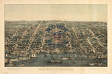
Experience Alexandria at one of the most dramatic moments in American history with this striking bird's eye view from 1863. Created by Charles Magnus during the height of the Civil War, this panoramic illustration captures the bustling port city under Union occupation, transformed into a vital supply and logistics hub for the Army of the Potomac.
A City Under Military Control
This meticulously detailed bird's eye view showcases Alexandria's strategic position on the Potomac River, just across from Washington, D.C. Every building, wharf, and street reveals a city adapting to wartime reality—military hospitals, supply depots, and troop encampments visible throughout. At upper left stands the distinctive domed depot of the Orange and Alexandria Railroad, a critical lifeline for Union forces. The map is indexed for points of interest, documenting not just civilian Alexandria but the extensive ring of fortifications and military installations that surrounded and protected the capital.
Historical Significance
By 1863, Alexandria had spent two years under Federal occupation, serving as a massive staging area for Union military operations in Virginia. The city's wharves handled thousands of tons of supplies daily, while its buildings housed military offices, hospitals, and warehouses. This same year, Alexandria became the seat of the Restored Government of Virginia—the Unionist government loyal to Washington—making it both a military and political center for the Union cause. This map captures that extraordinary transformation from peaceful river port to fortified military city, preserving a moment when Alexandria stood at the very center of the war's eastern theater.
Museum-Quality Reproduction
This is a high-quality reproduction of the original 1863 lithograph, professionally printed using museum-grade methods and materials to preserve every detail of this historic cartographic treasure.
Perfect For:
- History enthusiasts and collectors of Americana
- Virginia natives and Alexandria residents
- Anyone passionate about Civil War history
- Displaying alongside your military and historical collections
- Gift-giving for those who appreciate historical artifacts
Specifications:
- Original Publication: 1863
- Style: Bird's eye view perspective
- Features: Indexed points of interest, fortifications, military installations
- Product Type: High-Quality Reproduction Print
Dimensions (Width x Height): 25.4 x 17.1
Each map is printed using the finest materials and methods. Your map will be handled with white gloves from start to finish. We use the Giclee printing method on Hahnemuhle paper, which produces a clear, extremely detailed, durable map that is perfect to be proudly displayed in your home or office.
Digital watermark does not appear on your purchased map.


