


Colorado Springs, Colorado - 1909 Bird's Eye View Map
Colorado Springs, Colorado - 1909 Bird's Eye View Map
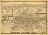
Experience Colorado Springs at the height of its transformation from frontier resort town to elegant mountain city with this stunning panoramic view from 1909. Published by the Benford-Bryan Publishing Company of Denver, this sweeping perspective captures the city nestled at the base of Pikes Peak during its golden age of prosperity and growth.
A Victorian Gem in the Shadow of Pikes Peak
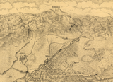
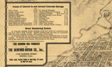
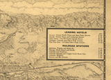
This meticulously detailed illustration showcases Colorado Springs' carefully planned street grid spreading across the high plains, with the majestic Pikes Peak dominating the skyline. Every structure—from grand hotels and sanitariums to elegant Victorian homes and commercial blocks—tells the story of a community built on health tourism, military presence, and silver mining wealth. The map's comprehensive index highlights points of interest throughout the city, offering a window into the landmarks and districts that made Colorado Springs one of America's most fashionable mountain destinations.
Historical Significance
By 1909, Colorado Springs had evolved from General Palmer's planned resort community into a thriving city known for its clean air, natural beauty, and wealthy residents. This map captures that belle époque moment—when magnificent hotels hosted eastern socialites seeking the healing mountain climate, when millionaires' mansions lined the avenues, and when the city served as the gateway to Pikes Peak and the Garden of the Gods. The map includes Fort Carson's predecessor military installations, foreshadowing the city's future as a major military hub.
Museum-Quality Reproduction
This is a high-quality reproduction of the original 1909 map, professionally printed using museum-grade methods and materials to preserve every detail of this historic cartographic treasure.
Perfect For:
- History enthusiasts and collectors of Americana
- Colorado natives and Colorado Springs residents
- Anyone passionate about Western expansion and frontier history
- Displaying alongside your military and historical collections
- Gift-giving for those who appreciate historical artifacts
Specifications:
- Original Publication: 1909
- Style: Perspective aerial view
- Features: Full-color illustration with indexed points of interest
- Product Type: High-Quality Reproduction Print
Dimensions 20 x 14.7
Each map is printed using the finest materials and methods. Your map will be handled with white gloves from start to finish. We use the Giclee printing method on Hahnemuhle paper, which produces a clear, extremely detailed, durable map that is perfect to be proudly displayed in your home or office.
Digital watermark does not appear on your purchased map.


