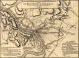
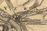


Trenton, New Jersey with Washington's Crossing - 1777 Battle Map
Trenton, New Jersey with Washington's Crossing - 1777 Battle Map
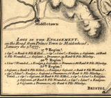
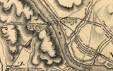
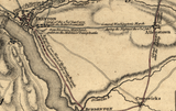
Examine one of the most decisive moments of the American Revolution with this detailed 1777 British military map documenting General George Washington’s surprise attack on Trenton and the winter campaign that followed. This historic operational map charts the movements of American and British forces from December 26, 1776 through January 3, 1777—ten critical days that reversed the fortunes of the Continental Army.
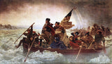
Historical Context At the close of 1776, the American Revolution stood on the brink of collapse. After a series of defeats, dwindling enlistments, and collapsing morale, Washington faced the near dissolution of his army. In a calculated gamble, he launched a winter offensive against Hessian forces stationed at Trenton, crossing the ice-choked Delaware River on Christmas night.
The initial victory at Trenton was followed by a rapid sequence of maneuvers as British forces under General Cornwallis attempted to trap Washington’s army. Over the next several days, Washington fought delaying actions, slipped past British lines, and struck again at Princeton, completing one of the most effective winter campaigns in military history.
The Map’s Features This British operational map presents the full campaign with precision, showing:
• Washington’s Delaware River crossing route
• American approach columns converging on Trenton
• Hessian cantonments and defensive positions
• British troop movements responding to the attack
• Engagements at Trenton, Assunpink Creek, and Princeton
• Roads, rivers, terrain, and towns critical to maneuver
The map captures not only the battles themselves, but the operational flow of the campaign as British commanders attempted—and failed—to counter Washington’s movements.
Historical Significance The Trenton campaign marked the turning point of the Revolutionary War. The surprise victory shattered the perception of British invincibility, restored American morale, and convinced many that independence remained achievable. This map preserves the British perspective of the campaign, documenting both Washington’s audacity and the challenges faced by British forces confronting unconventional winter warfare.
Museum-Quality Reproduction This is a high-quality reproduction of the original 1777 British military map, professionally printed using museum-grade methods and materials to preserve every detail of this historic operational document. Each piece is produced on archival Hahnemühle paper using the Giclée printing process, ensuring exceptional clarity, durability, and a refined finish suitable for display.
Perfect For
• Revolutionary War and colonial history enthusiasts
• Students of George Washington’s military leadership
• Educational displays on America’s founding
• Offices, libraries, and study spaces
• Gifts for historians and patriots
Specifications
• Original Publication: 1777
• Created By: British military cartographers
• Style: 18th-century operational military map
• Coverage: December 26, 1776 – January 3, 1777
• Features: Washington’s crossing route, troop movements, Hessian positions, engagements at Trenton and Princeton
• Product Type: High-Quality Reproduction Print
• Scale: 1:115,000
• Dimensions (Width x Height): 15.5 × 11.5
Each map is printed using the finest materials and methods. Your map will be handled with white gloves from start to finish. We use the Giclée printing method on Hahnemühle paper, which produces a clear, extremely detailed, durable map perfect for proud display in your home or office.
Digital watermark does not appear on your purchased map.


