


Normandy Omaha Beach - 1944 Battle Map
Normandy Omaha Beach – 1944 Battle Map
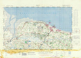
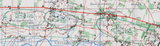
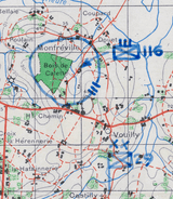
Examine the most contested sector of the D-Day landings with this detailed tactical map documenting American forces fighting inland from Omaha Beach on June 6, 1944. This operational map records unit positions, movements, and objectives as U.S. troops broke through German defenses and secured a foothold on the Normandy coast.
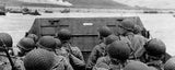
Historical Context Omaha Beach was the most heavily defended and costly of the five Allied landing zones during Operation Overlord. Strong German fortifications, steep bluffs, and overlapping fields of fire inflicted severe casualties on the first assault waves. Despite near-collapse in the early hours, small-unit leadership and improvised attacks gradually overcame the defenses, allowing American forces to push inland by the end of the day.
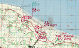
This map captures the situation after the initial landings, showing how the battle transitioned from chaos on the beach to coordinated movement inland as exits were secured and German strongpoints neutralized.
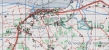
The Map’s Features This tactical battle map presents the Omaha Beach sector in exceptional detail, showing American unit locations along the coastline, inland advance routes, German defensive positions, road networks, terrain features, and key objectives. Unit symbols and annotations identify elements of the U.S. 1st Infantry Division and 29th Infantry Division as they moved through draws, across open ground, and into surrounding villages. The map documents the hard-fought progress inland that transformed Omaha from a stalled landing into a secured beachhead.
Historical Significance Omaha Beach tested the success of the entire Normandy invasion. Failure to break through would have left Allied forces divided and vulnerable. By nightfall on June 6, despite heavy losses, American units had secured critical exits and established inland positions. This map preserves the operational reality of that achievement, documenting how determination, leadership, and adaptability overcame one of the strongest defensive belts in occupied Europe.
Museum-Quality Reproduction This is a high-quality reproduction of the original 1944 tactical battle map, professionally printed using museum-grade methods and materials to preserve every detail of this historic operational document. Each piece is produced on archival Hahnemühle paper using the Giclée printing process, ensuring exceptional clarity, durability, and a refined finish suitable for display.
Perfect For World War II and D-Day historians; military professionals and students of amphibious warfare; veterans and families honoring the Greatest Generation; educational displays on Operation Overlord; offices, libraries, and study spaces; gifts for military history collectors.
Specifications
• Original Publication: 1944
• Style: Tactical battle map showing unit positions and movements
• Features: American unit locations, German defensive positions, terrain features, inland advance routes
• Product Type: High-Quality Reproduction Print
• Dimensions (Width x Height): 30 × 22.1
Each map is printed using the finest materials and methods. Your map will be handled with white gloves from start to finish. We use the Giclée printing method on Hahnemühle paper, which produces a clear, extremely detailed, durable map perfect for proud display in your home or office.
Digital watermark does not appear on your purchased map.


