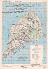
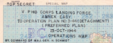


Iwo Jima, Japan – 1945 U.S. Assault Plan Battle Map
Iwo Jima, Japan – 1945 U.S. Assault Plan Battle Map
Examine the strategic planning behind one of World War II’s most intense and consequential battles with this detailed U.S. assault plan of Iwo Jima. Published in November 1944 in preparation for the coming invasion, this historic military map outlines the landing beaches, assault sectors, terrain challenges, and defensive positions that would shape the February 1945 battle.
Historical Context
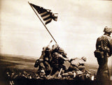
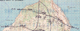
By late 1944, Iwo Jima had become a critical objective for Allied forces advancing toward the Japanese home islands. Located between the Mariana Islands and mainland Japan, the island provided early-warning radar and interceptor bases that threatened U.S. bombing operations. Securing Iwo Jima was essential for establishing emergency landing fields and tightening Allied control of the Pacific. When the invasion began on February 19, 1945, U.S. Marines encountered heavily fortified volcanic terrain, extensive tunnel networks, and determined defenders. This assault plan map—published months before the landings—captures how the battle was expected to unfold before the realities of combat set in.
The Map’s Features
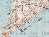
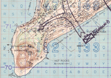
This operational planning map presents the intended U.S. Marine assault with clarity and precision, showing designated landing beaches, color-coded assault sectors, amphibious approach routes, naval gunfire support zones, initial unit landing assignments, airfields, roads, ridgelines, volcanic terrain including Mount Suribachi, and known Japanese defensive positions. Military symbology and structured layout reflect the professional cartographic standards used by U.S. Army engineers during the final year of the Pacific War.
Historical Significance
The Battle of Iwo Jima remains one of the most significant and costly engagements in U.S. Marine Corps history. This map preserves the strategic framework behind the assault, allowing viewers to understand the scale, complexity, and assumptions that shaped the operation before the first Marines went ashore. For historians and collectors, it serves as both a technical military document and a solemn tribute to the sacrifices made during the Pacific campaign.
Museum-Quality Reproduction
This is a high-quality reproduction of the original World War II military map, professionally printed using museum-grade methods and materials to preserve every detail of this historic operational document. Each piece is produced on archival Hahnemühle paper using the Giclée printing process, ensuring exceptional clarity, durability, and a refined finish suitable for display in any setting.
Perfect For
• World War II and Pacific Theater historians
• Military professionals and veterans
• Battle map and cartography collectors
• Offices, libraries, and study spaces
• Gifts for Marines and military families
• Commemorative displays honoring WWII service
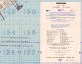
Specifications
• Battle Result: American Victory
• Original Publication: November 1944
• Publisher: 64th Engineer Topographic Battalion, U.S. Army Forces Central Pacific
• Style: WWII U.S. operational planning map
• Product Type: High-Quality Reproduction Print
• Scale: 10,000
• Dimensions (Width x Height): 24 x 34.9
Each map is printed using the finest materials and methods. Your map will be handled with white gloves from start to finish. We use the Giclée printing method on Hahnemühle paper, which produces a clear, extremely detailed, durable map perfect for proud display in your home or office.
Digital watermark does not appear on your purchased map.


