


West Point, New York – 1783 Map with the Great Chain
West Point, New York – 1783 Map with the Great Chain
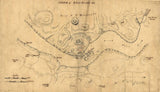
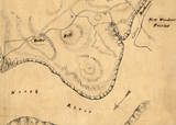
This 1783 map of West Point captures one of the most strategically vital positions of the American Revolutionary War. Stretching across the Hudson River—labeled the “North River” on this map—is the famous Great Chain, a massive iron barrier designed to prevent British warships from sailing north and dividing the colonies.
Historical Context West Point sat at a commanding bend in the Hudson, making it the key to controlling movement between New England and the rest of the colonies. In 1778, under General George Washington’s direction, the Continental Army installed the Great Chain across the river, anchoring it to fortified positions on both banks. The barrier, combined with artillery placed on surrounding high ground, turned the river into a defensive stronghold. In 1802, this same strategic location became home to the United States Military Academy.
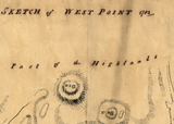
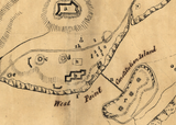
The Map’s Features The map shows the Hudson River’s sharp bend, defensive fortifications, artillery positions, surrounding highlands, and the Great Chain stretched across the water. Hand-drawn terrain markings illustrate the steep elevations that made West Point nearly impregnable. Early American cartographic styling and period labeling give the piece an authentic Revolutionary War character.
Historical Significance West Point was never successfully taken by the British. Its defenses preserved the critical Hudson corridor and helped secure the northern theater of the war. This map represents both early American military engineering and the birthplace of what would become one of the most important military academies in the world.
Museum-Quality Reproduction This is a high-quality reproduction of the original 1783 map, professionally printed on archival Hahnemühle paper using the Giclée printing process to preserve the fine line work, aged tone, and period details for generations.
Perfect For:
• Revolutionary War historians and collectors
• West Point graduates and military families
• Veterans and active-duty service members
• Offices, studies, and patriotic home displays
• Gifts honoring American military heritage
Specifications:
• Created/Published: 1783
• Scale: 20,000
• Conflict: American Revolutionary War
• Product Type: High-Quality Reproduction Print
Dimensions (Width x Height): 22.6 x 13.1
Each map is printed using the finest materials and methods. Your map will be handled with white gloves from start to finish. We use the Giclée printing method on Hahnemühle paper, which produces a clear, extremely detailed, durable map perfect for proud display in your home or office.
Digital watermark does not appear on your purchased map.


