


Carentan, France – 1944 Topographical Military Map
Carentan, France – 1944 Topographical Military Map
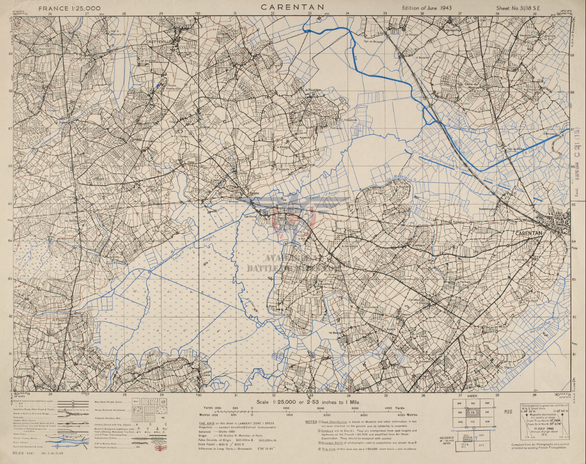
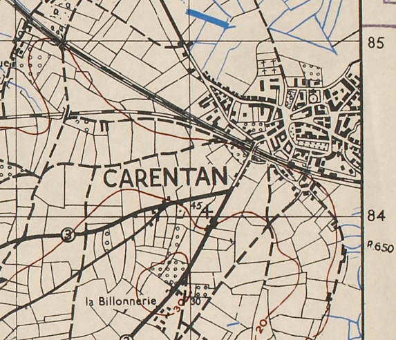
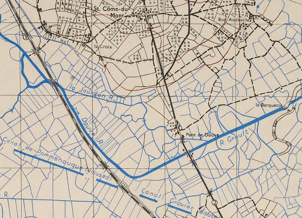
For a paratrooper of the 101st Airborne Division in the summer of 1944, the road to Carentan ran across flooded causeways with no cover and no way back. The men of the 506th Parachute Infantry Regiment — among them Easy Company, whose service would later be documented in Band of Brothers — advanced on that narrow corridor knowing every yard exposed them to direct fire. Carentan was the prize: a Norman market town that stood between Utah Beach and Omaha Beach, the only viable land bridge between two Allied beachheads that could not survive in isolation. This Allied topographical map, produced in 1943 by military cartographers preparing for the invasion of Europe, documents the ground those paratroopers crossed — every canal, road junction, and hedgerow — exactly as they encountered it.
Historical Context In the predawn hours of June 6, 1944, the 101st Airborne Division descended over the flooded lowlands west of Utah Beach, scattered across fractured drop zones and tasked with securing the causeways leading inland. Among the units assigned to seize Carentan was the 506th Parachute Infantry Regiment, whose 2nd Battalion — including Easy Company — would fight its way to the town over the following week. The German defense was organized around the 6th Fallschirmjäger Regiment under Major Friedrich von der Heydte, a veteran parachute commander who used Carentan's surrounding marshland and drainage canals to channel every Allied approach under concentrated fire. The assault on the town required American paratroopers to advance along exposed causeways for days, taking sustained casualties before breaching the German perimeter. Carentan fell on June 12, 1944, and the 506th PIR continued southwest to consolidate the bridgehead; a German armored counterattack the following day was repulsed with reinforcements. The link between Utah and Omaha was secured, and Normandy became a continuous Allied front.
The Map's Features This 1:25,000 scale military topographical map was produced by Allied cartographers in June 1943 — more than a year before the invasion — as part of the systematic survey of Normandy in preparation for Operation Overlord. Blue ink marks the Douve River, drainage canals, and the extensive marshland that made Carentan's natural approaches so difficult to exploit, while the dense field boundaries, hedgerows, and farm roads of the Norman bocage are rendered with the precision required for infantry navigation. The main road and rail corridors into Carentan from the northwest are clearly visible — the same axes the 506th PIR used in their approach to the town — along with the junction routes continuing southwest that the 101st Airborne secured after the capture. Elevation contours define the gentle ridgelines controlling observation across the lowland approaches, and the map carries the printed notation "Edition of June 1943," placing it squarely in the Allied pre-invasion cartographic effort.
Historical Significance The capture of Carentan on June 12, 1944 was the act that consolidated the D-Day landings as a viable campaign. Without the link between Utah and Omaha, the Allied beachheads remained vulnerable to defeat in detail — isolated, under-resourced, and exposed. The six days of fighting to take Carentan cost the 101st Airborne Division heavily, and the German armored counterattack on June 13 came dangerously close to retaking it before the line held. For the men of the 506th PIR who crossed those causeways under fire, Carentan was not a secondary objective — it was the fight that proved Normandy would not be thrown back into the sea. This map preserves the operational ground as Allied commanders understood it in the days surrounding that engagement: the terrain, the roads, the water, and the landscape that shaped every tactical decision.
Framing Options This map is available unframed or professionally framed and ready to hang. Our framing partner uses museum-quality materials to protect and present your print for long-term display. Choose from a classic Black frame or a warm Walnut Brown frame — both available with your order. Please allow 3–4 weeks for delivery on framed orders.
Museum-Quality Reproduction This is a high-quality reproduction of the original historic map, professionally printed on archival Hahnemühle paper using the Giclée printing process to preserve fine cartographic detail, line clarity, and period authenticity for long-term display.
Perfect For:
- Veterans and families of the 101st Airborne Division and 506th Parachute Infantry Regiment
- Band of Brothers viewers and WWII European Theater historians
- Collectors of D-Day and Normandy campaign maps
- Offices, studies, and libraries with a focus on WWII military history
- Gifts for veterans, history enthusiasts, and anyone with a family connection to the Normandy campaign
Specifications:
- Original Publication: June 1943
- Publisher: Geographical Section, General Staff (GSGS) — Allied Forces
- Style: WWII Allied military topographical map
- Battle/Conflict: Battle of Carentan, Normandy Campaign (WWII)
- Battle Result: Allied Victory (June 1944)
- Scale: 1:25,000
- Product Type: High-Quality Reproduction Print
Dimensions (Width x Height): 20 x 15.9
Each map is printed using the finest materials and methods. Your map will be handled with white gloves from start to finish. We use the Giclée printing method on Hahnemühle paper, which produces a clear, extremely detailed, durable map perfect for proud display in your home or office.
Choose options
