


Antietam (Sharpsburg), Maryland – 1862 Battle Map
Antietam (Sharpsburg), Maryland – 1862 Battle Map
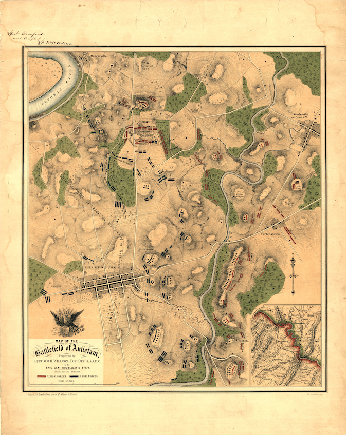
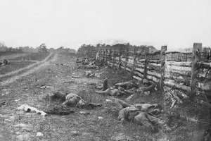
On September 17, 1862, the fields and woodlots northwest of Sharpsburg, Maryland absorbed more American blood than any single day in the nation's military history. Union Major General George B. McClellan's Army of the Potomac struck General Robert E. Lee's Army of Northern Virginia along Antietam Creek, pressing three successive assaults across the Cornfield, the Sunken Road, and the Lower Bridge. When darkness ended the fighting, more than 22,000 men were dead, wounded, or missing — a toll that remains unmatched in American warfare. This map, prepared in 1862, documents the battlefield as it stood that day: a landscape of farms and creek crossings transformed in a single afternoon into one of the war's defining confrontations.
Historical Context Antietam was the culmination of Lee's first invasion of Northern soil. Following a string of Confederate victories in Virginia, Lee moved the Army of Northern Virginia into Maryland in early September 1862, seeking to shift the war's burden northward, threaten Washington, and potentially gain European recognition for the Confederacy. McClellan, in possession of a copy of Lee's operational orders, moved to intercept. The battle that followed unfolded in three distinct phases across the length of the Confederate line — each assault initially threatening a breakthrough that Union coordination could not sustain. When Lee withdrew his battered army to Virginia on September 18, Lincoln claimed the outcome as sufficient military success to issue the Emancipation Proclamation five days later, irrevocably changing the political character of the war.
The Map's Features This battlefield map presents the full operational disposition of Union and Confederate forces along Antietam Creek, rendered with the precision of a staff officer's working document. Unit positions are plotted across the key terrain corridors — the Cornfield, the Sunken Road, Burnside Bridge, and the high ground anchoring Lee's center — with commanders identified by name, including Lee, Jackson, Doubleday, McClellan, and Meade. Road networks, creek crossings, and the agricultural landscape of the Sharpsburg area are rendered in period cartographic style, providing the topographic context essential to understanding why each phase of the battle developed where it did. The map was prepared by Lieutenant William H. Willcox, Topographical Officer and Assistant Aide-de-Camp on Brigadier General Doubleday's staff — an officer present on the field.
Historical Significance Antietam did not end the war, but it foreclosed the strategic options that might have shortened it in the Confederacy's favor. Lee's withdrawal denied the South the decisive foreign recognition it had sought, and Lincoln's Emancipation Proclamation — issued in the battle's wake — reframed the conflict before a global audience, making European intervention politically untenable. For students of the Civil War, Antietam represents the moment the war became irrevocably a contest over slavery's survival, not merely over Union. This map preserves the battlefield configuration at that hinge point — the ground on which 22,000 Americans fell and the political direction of the war was settled.
Framing Options This map is available unframed or professionally framed and ready to hang. Our framing partner uses museum-quality materials to protect and present your print for long-term display. Choose from a classic Black frame or a warm Walnut Brown frame — both available with your order. Please allow 3–4 weeks for delivery on framed orders.
Museum-Quality Reproduction This is a high-quality reproduction of the original historic map, professionally printed on archival Hahnemühle paper using the Giclée printing process to preserve fine cartographic detail, line clarity, and period authenticity for long-term display.
Perfect For:
- Civil War historians and American military history collectors
- Veterans, military families, and descendants with connections to the Maryland Campaign
- Scholars of Civil War strategy and the Emancipation Proclamation
- Home offices, studies, libraries, and heritage displays
- Gifts honoring Civil War service and American military history
Specifications:
- Original Publication: 1862
- Cartographer: Lieutenant William H. Willcox, Topographical Officer & A.A.D.C., Doubleday's Staff
- Style: Civil War battlefield operational map
- Battle/Conflict: Battle of Antietam (American Civil War)
- Battle Result: Inconclusive
- Product Type: High-Quality Reproduction Print
Dimensions (Width x Height): 19 x 24 in
Each map is printed using the finest materials and methods. Your map will be handled with white gloves from start to finish. We use the Giclée printing method on Hahnemühle paper, which produces a clear, extremely detailed, durable map perfect for proud display in your home or office.
Choose options
