


Iwo Jima, Japan – Comprehensive Battle Map with Order of Battle
Iwo Jima, Japan – Comprehensive Battle Map with Order of Battle
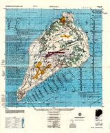
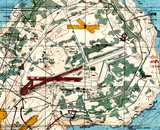
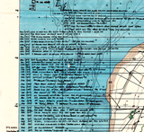
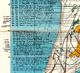
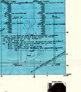
This exceptionally detailed battle map presents one of the most complete visual and analytical depictions of the Battle of Iwo Jima available, combining precise cartography with extensive written battle annotations. Built on a 1954 base map of the island and augmented with research and commentary added during the mid-to-late 1980s, this map traces the assault down to the company level—showing exactly where and in what sequence U.S. Marine units landed, advanced, and engaged across the island.
Historical Context
The Battle of Iwo Jima was fought from 19 February to 26 March 1945 in the Volcano Islands, roughly 750 miles south of Tokyo, and was waged entirely by U.S. Marine Corps and U.S. Navy forces. Intended to secure airfields for emergency landings and reduce Japanese early-warning capabilities, the battle became one of the bloodiest engagements in Marine Corps history. Uniquely, Iwo Jima resulted in more American casualties than Japanese, underscoring the ferocity of the fighting and the depth of Japan’s defensive preparations. The battle is forever etched into history through Joe Rosenthal’s iconic photograph, Raising the Flag on Iwo Jima.
The Map’s Features
This large-format operational map goes far beyond standard battlefield depictions, presenting an extraordinary level of detail, including:
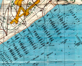
• Company-level landing sequences showing where units hit the beaches and in what order
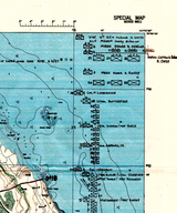
• Daily and near-daily written annotations describing combat actions across the island
• Casualty figures tied to specific phases and positions in the fight
• Beach sectors, inland axes of advance, and key tactical objectives
• Airfields, terrain features, defensive zones, and operational reference information
• A documented order of battle that allows the campaign to be followed step-by-step
Historical Significance
Unlike contemporaneous wartime maps focused on planning or immediate reporting, this postwar analytical map reflects decades of accumulated research and perspective on Iwo Jima. It is an unusually rich single-sheet synthesis of cartography and historical analysis—letting viewers track the battle at the tactical level while also absorbing the narrative and cost of the campaign as it unfolded. For collectors and historians, it functions as both a battlefield map and an authoritative reference document.
Museum-Quality Reproduction
This is a high-quality reproduction of the original annotated battle map, professionally printed using museum-grade methods and materials to preserve the extraordinary level of detail contained in the original. Each piece is produced on archival Hahnemühle paper using the Giclée printing process, ensuring exceptional clarity, durability, and a refined finish suitable for display in any setting.
Perfect For:
• World War II and Pacific Theater historians
• U.S. Marine Corps veterans and military families
• Military professionals, educators, and students
• Battle map and cartography collectors
• Libraries, offices, and study spaces
• Serious collectors seeking definitive Iwo Jima documentation
Specifications:
• Battle Result: American Victory
• Created / Published: Late 1980s (annotations) with 1954 base map
• Style: Postwar analytical battle map with order of battle
• Product Type: High-Quality Reproduction Print
• Scale: 1:12,500
Dimensions (Width x Height): 22 x 26.7
Each map is printed using the finest materials and methods. Your map will be handled with white gloves from start to finish. We use the Giclée printing method on Hahnemühle paper, which produces a clear, extremely detailed, durable map perfect for proud display in your home or office.
Digital watermark does not appear on your purchased map.


