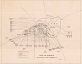


Iwo Jima, Japan – 1945 Naval Bombardment Fire Support Map
Iwo Jima, Japan – 1945 Naval Bombardment Fire Support Map
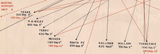
Examine the naval firepower that supported one of World War II’s most brutal amphibious assaults with this detailed U.S. Navy bombardment plan for the Battle of Iwo Jima. Created during the 1945 campaign, this operational map outlines naval gunfire sectors, ammunition allocations, and ship responsibilities supporting Marine landings and inland advances across the island.
Historical Context
The Battle of Iwo Jima was fought from February 19 to March 26, 1945, in the Volcano (Bonin) Islands approximately 750 miles south of Tokyo. The battle was fought almost entirely by the U.S. Marine Corps with extensive naval support and resulted in one of the highest casualty rates of the Pacific War, with American losses exceeding those of the Japanese defenders. Naval bombardment was a critical component of the operation, intended to suppress fortified positions, cave networks, and defensive strongpoints embedded in Iwo Jima’s volcanic terrain prior to and during the ground assault.
The Map’s Features
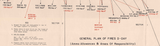
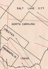
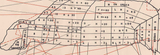
This naval bombardment map details the fire support structure supporting the invasion, showing designated bombardment sectors, naval gunfire areas of responsibility, and ammunition allotments assigned to individual ships. It illustrates how offshore fire was coordinated with Marine ground operations and highlights the layered planning required to support sustained combat on a small, heavily fortified island. The map also identifies major supporting vessels, including USS Tennessee and USS Nevada—both survivors of the attack on Pearl Harbor—and USS Indianapolis, later lost in 1945 after delivering components of the first atomic bomb.
Historical Significance
Naval gunfire played a decisive role in enabling Marine advances across Iwo Jima’s beaches and interior defenses. This map preserves the operational framework behind that support, offering insight into the scale, precision, and coordination required to sustain ground forces under extreme combat conditions. For historians and collectors, it documents the often unseen offshore dimension of the battle and honors the naval crews whose fire support proved essential to eventual victory.
Museum-Quality Reproduction
This is a high-quality reproduction of the original World War II naval operational map, professionally printed using museum-grade methods and materials to preserve every detail of this historic fire support document. Each piece is produced on archival Hahnemühle paper using the Giclée printing process, ensuring exceptional clarity, durability, and a refined finish suitable for display in any setting.
Perfect For
• World War II and Pacific Theater historians
• U.S. Navy and Marine Corps veterans and families
• Iwo Jima and naval warfare collectors
• Offices, libraries, and study spaces
• Gifts honoring naval and Marine service
• Displays focused on amphibious and fire support operations
Specifications
• Battle Result: American Victory
• Created / Published: 1945
• Style: Mid-20th-century naval bombardment operational map
• Product Type: High-Quality Reproduction Print
• Dimensions (Width x Height): 18.7 x 14.8
Each map is printed using the finest materials and methods. Your map will be handled with white gloves from start to finish. We use the Giclée printing method on Hahnemühle paper, which produces a clear, extremely detailed, durable map perfect for proud display in your home or office.
Digital watermark does not appear on your purchased map.


