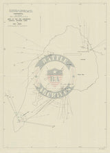


Iwo Jima, Japan – 1945 Coastal Defense Gun Emplacements Battle Map
Iwo Jima, Japan – 1945 Coastal Defense Gun Emplacements Battle Map
Examine the defensive firepower that confronted U.S. Marines during the assault on Iwo Jima with this detailed coastal defense analysis map showing the arcs of fire for Japanese casemated artillery positions. This technical military document reveals how the island’s coastal guns were positioned to dominate approaches by sea and create lethal interlocking fields of fire against amphibious landings.
Historical Context
The Battle of Iwo Jima was fought from February 19 to March 26, 1945 in the Volcano Islands, approximately 750 miles south of Tokyo. Japanese defenders transformed the island into a heavily fortified stronghold, embedding artillery, mortars, and machine guns into reinforced concrete positions designed to survive prolonged bombardment. Coastal defense guns were a critical component of this system, intended to break up landing formations and inflict maximum casualties before Marines could establish a foothold ashore.
The Map’s Features
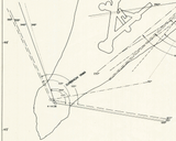
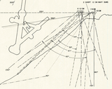
This battle map plots the precise locations of casemated coastal defense guns and traces their individual arcs of fire across the surrounding waters and landing beaches. Lines radiating from each emplacement illustrate overlapping kill zones, making clear how Japanese planners engineered a layered defensive network. The concentration of fire directed toward the southern beaches and Mount Suribachi highlights why neutralizing these positions became an immediate priority during the opening phase of the assault.
Historical Significance
Maps like this explain why Iwo Jima proved so costly despite overwhelming American naval and air superiority. The visual density of overlapping artillery coverage demonstrates how Japanese defenses were designed not merely to repel landings, but to exact a devastating toll even under sustained bombardment. When viewed alongside assault plans and front-line progression maps, this document provides critical insight into the defensive logic that shaped one of the bloodiest battles in Marine Corps history.
Museum-Quality Reproduction
This is a high-quality reproduction of the original World War II military map, professionally printed using museum-grade methods and materials to preserve every detail of this historic operational document. Each piece is produced on archival Hahnemühle paper using the Giclée printing process, ensuring exceptional clarity, durability, and a refined finish suitable for display in any setting.
Perfect For
• World War II and Pacific Theater historians
• U.S. Marine Corps veterans and families
• Amphibious warfare and coastal defense researchers
• Military engineering and fortifications enthusiasts
• Offices, libraries, and study spaces
• Displays honoring WWII service and sacrifice
Specifications
• Battle Result: American Victory
• Style: Mid-20th-century coastal defense and artillery analysis map
• Product Type: High-Quality Reproduction Print
• Dimensions (Width x Height): 14 x 19.4
Each map is printed using the finest materials and methods. Your map will be handled with white gloves from start to finish. We use the Giclée printing method on Hahnemühle paper, which produces a clear, extremely detailed, durable map perfect for proud display in your home or office.
Digital watermark does not appear on your purchased map.


