


Iwo Jima, Japan – 1945 Hand-Drawn Amphibious Assault and Advance Battle Map
Iwo Jima, Japan – 1945 Hand-Drawn Amphibious Assault and Advance Battle Map
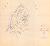
Examine the Battle of Iwo Jima through a hand-drawn operational overview that captures the full scope of the amphibious assault, air support, and inland advance across the island. This map presents the battle as a dynamic, multi-domain operation, illustrating how naval forces, aircraft, and Marine units converged on one of the most heavily defended objectives of the Pacific War.
Historical Context
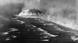
The Battle of Iwo Jima was fought from February 19 to March 26, 1945 in the Volcano Islands, approximately 750 miles south of Tokyo. U.S. forces launched a massive amphibious assault against deeply entrenched Japanese defenders who had transformed the island into a fortress of bunkers, tunnels, and concealed artillery positions. Despite overwhelming naval and air superiority, progress inland was slow, costly, and fiercely contested.
The Map’s Features
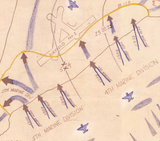
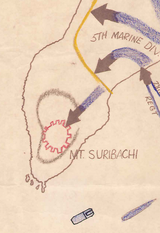
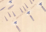
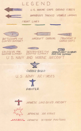
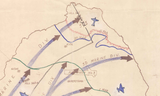
This hand-drawn battle map depicts amphibious landing waves approaching the southern beaches, coordinated naval gunfire support, and aerial activity over the island. Arrows trace the inland advance of Marine units as they pushed northward from the landing zones, while symbols indicate supporting naval vessels and aircraft operating offshore. The map visually integrates sea, air, and ground actions into a single operational narrative, emphasizing the complexity of the assault.
Historical Significance
Hand-drawn maps like this were often used to synthesize rapidly changing battlefield information into a coherent picture for planners and commanders. This document highlights the reality of amphibious warfare at Iwo Jima, where carefully planned assaults met brutal resistance and required constant adaptation. When viewed alongside the assault planning maps and front-line progression charts, it underscores the immense difficulty of translating operational intent into battlefield success.
Museum-Quality Reproduction
This is a high-quality reproduction of the original World War II military map, professionally printed using museum-grade methods and materials to preserve every detail of this historic operational document. Each piece is produced on archival Hahnemühle paper using the Giclée printing process, ensuring exceptional clarity, durability, and a refined finish suitable for display in any setting.
Perfect For
• World War II and Pacific Theater historians
• U.S. Marine Corps veterans and families
• Amphibious warfare and naval history collectors
• Students of combined-arms operations
• Offices, libraries, and study spaces
• Displays honoring WWII service and sacrifice
Specifications
• Battle Result: American Victory
• Created / Published: 1945
• Style: Mid-20th-century hand-drawn operational battle map
• Product Type: High-Quality Reproduction Print
• Dimensions (Width x Height): 25.7 x 24
Each map is printed using the finest materials and methods. Your map will be handled with white gloves from start to finish. We use the Giclée printing method on Hahnemühle paper, which produces a clear, extremely detailed, durable map perfect for proud display in your home or office.
Digital watermark does not appear on your purchased map.


