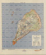


Iwo Jima, Japan – 1944 Japanese Defensive Positions Battle Map
Iwo Jima, Japan – 1944 Japanese Defensive Positions Battle Map
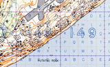
Examine the intelligence assessment that preceded one of World War II’s most costly amphibious assaults with this detailed pre-invasion map of Japanese defensive positions on Iwo Jima. Created in 1944 prior to the February 1945 landings, this historic military document reflects Allied efforts to identify and catalogue enemy fortifications before the opening bombardment and ground assault.
Historical Context
The Battle of Iwo Jima was fought from February 19 to March 26, 1945, in the Volcano (Bonin) Islands roughly 750 miles south of Tokyo. The island’s strategic location made it a critical objective for U.S. forces advancing toward the Japanese home islands. Anticipating heavy resistance, Allied planners devoted significant intelligence resources to understanding Iwo Jima’s defensive network before the invasion began. This map was produced as part of that effort, attempting to record known and suspected Japanese defensive positions prior to bombardment and landing operations.
The Map’s Features
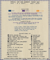
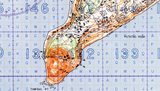
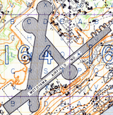
This pre-assault defensive map presents a comprehensive view of Japanese fortifications across the island, showing annotated defensive positions, terrain features, and coastal areas expected to be contested during the invasion. The map reflects intelligence gathered before combat began, illustrating how planners attempted to anticipate resistance from bunkers, artillery positions, and fortified zones embedded within Iwo Jima’s volcanic landscape. Its gridded layout and symbology demonstrate the analytical approach used to prepare for large-scale amphibious warfare.
Historical Significance
Despite extensive planning, many Japanese defenses—particularly underground tunnel systems—proved more extensive than anticipated. This map captures the limits of pre-invasion intelligence and helps explain why the battle unfolded with such ferocity and cost. For historians and collectors, it offers a rare snapshot of Allied expectations before combat, highlighting the challenges of intelligence gathering and the uncertainty faced by planners prior to the landings.
Museum-Quality Reproduction
This is a high-quality reproduction of the original World War II military intelligence map, professionally printed using museum-grade methods and materials to preserve every detail of this historic operational document. Each piece is produced on archival Hahnemühle paper using the Giclée printing process, ensuring exceptional clarity, durability, and a refined finish suitable for display in any setting.
Perfect For
• World War II and Pacific Theater historians
• Intelligence and military planning enthusiasts
• Iwo Jima and Marine Corps collectors
• Offices, libraries, and study spaces
• Gifts honoring U.S. military service
• Displays focused on pre-assault planning and battlefield analysis
Specifications
• Battle Result: American Victory
• Created / Published: 1944
• Style: Mid-20th-century military intelligence and defensive planning map
• Product Type: High-Quality Reproduction Print
• Scale: 1:20,000
• Dimensions (Width x Height): 18.4 x 22.1
Each map is printed using the finest materials and methods. Your map will be handled with white gloves from start to finish. We use the Giclée printing method on Hahnemühle paper, which produces a clear, extremely detailed, durable map perfect for proud display in your home or office.
Digital watermark does not appear on your purchased map.


