


Iwo Jima, Japan – 1945 Bonin Islands Japanese Military Map
Iwo Jima, Japan – 1945 Bonin Islands Japanese Military Map
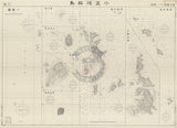
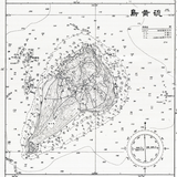
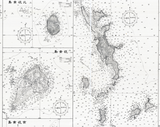
Examine the broader geographic and strategic context of the Battle of Iwo Jima through this rare Japanese-produced military map of the Bonin (Volcano) Islands. Created during World War II, this map presents the island chain from the defender’s perspective, situating Iwo Jima within the wider network of islands that formed Japan’s outer defensive perimeter in the Pacific.
Historical Context
The Battle of Iwo Jima was fought from February to March 1945 in the Volcano Islands, approximately 750 miles south of Tokyo. While the fighting focused intensely on Iwo Jima itself, the island was only one component of a broader island system that Japan relied upon for early warning, defense in depth, and control of Pacific approaches. This map reflects Japanese military awareness of the strategic importance of the Bonin Islands as a chain rather than a single battlefield.
The Map’s Features
This Japanese military map depicts the Bonin Islands in detail, showing individual islands, surrounding waters, navigational references, and coastal contours. The cartographic style emphasizes geographic relationships across the island chain, illustrating how Iwo Jima fit into Japan’s broader defensive geography. Compass roses, grid references, and careful shoreline rendering reflect Japanese naval and military mapping practices of the period.
Historical Significance
Maps such as this highlight the enemy’s understanding of the operational environment prior to the American invasion. By presenting Iwo Jima within the full Bonin Islands system, the map underscores why the island held such strategic value and why its loss was so significant to Japan’s Pacific defenses. For historians and collectors, it offers a rare opportunity to view the campaign from the opposing side’s geographic perspective.
Museum-Quality Reproduction
This is a high-quality reproduction of the original Japanese World War II military map, professionally printed using museum-grade methods and materials to preserve every detail of this historic cartographic document. Each piece is produced on archival Hahnemühle paper using the Giclée printing process, ensuring exceptional clarity, durability, and a refined finish suitable for display in any setting.
Perfect For
• World War II and Pacific Theater historians
• Iwo Jima and Bonin Islands collectors
• Military cartography and intelligence enthusiasts
• Offices, libraries, and study spaces
• Displays exploring enemy perspectives in WWII
• Gifts honoring historical scholarship
Specifications
• Battle Result: American Victory
• Style: Japanese World War II military map
• Product Type: High-Quality Reproduction Print
• Dimensions (Width x Height): 33 x 24
Each map is printed using the finest materials and methods. Your map will be handled with white gloves from start to finish. We use the Giclée printing method on Hahnemühle paper, which produces a clear, extremely detailed, durable map perfect for proud display in your home or office.
Digital watermark does not appear on your purchased map.


