


Washington, D.C. and the Seat of War on the Potomac – 1861 Civil War View
Washington, D.C. and the Seat of War on the Potomac – 1861 Civil War View
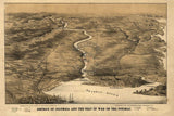
Experience the nation’s capital at the dawn of the Civil War with this striking 1861 panoramic view of the District of Columbia and the Potomac River corridor. Created as the country descended into conflict, this detailed perspective map captures Washington not only as a political capital, but as a strategic military landscape at the moment it became the Union’s most critical objective to defend.
Historical Context In 1861, Washington, D.C. stood perilously close to Confederate territory. Virginia’s secession placed enemy forces just across the Potomac, forcing the Union to rapidly fortify and secure the capital. Roads, rail lines, river crossings, and surrounding towns suddenly took on immense military importance as federal authorities prepared for war.
This map reflects that moment of transformation. Rather than focusing on battlefield lines alone, it presents Washington and its approaches as an interconnected strategic system—showing how geography, infrastructure, and terrain shaped the defense of the capital during the opening months of the Civil War.
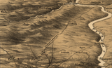
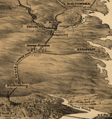
The Map’s Features This evocative perspective rendering presents the District of Columbia from the southeast, offering a sweeping view of the Potomac River basin and the key routes leading into the city. Prominent locations include Arlington House overlooking the river, the port city of Alexandria, the approaches at Bladensburg and Chain Bridge, and inland towns such as Rockville. Roads, railroads, waterways, and settlements are carefully illustrated, emphasizing how transportation networks and elevation defined military movement and defense. The artistic style blends cartography with landscape illustration, giving the map both analytical and visual impact.
Historical Significance During the Civil War, Washington became one of the most heavily fortified cities in the world. This 1861 view preserves the capital before those defenses fully reshaped the landscape, capturing the vulnerable geography that Union planners raced to protect. For historians and collectors, the map offers a rare strategic snapshot of Washington at the moment it transitioned from civic center to wartime stronghold—an essential perspective on how the Civil War reshaped the nation’s capital.
Museum-Quality Reproduction This is a high-quality reproduction of the original 1861 map, professionally printed using museum-grade methods and materials to preserve every detail of this historic perspective view. Each piece is produced on archival Hahnemühle paper using the Giclée printing process, ensuring exceptional clarity, durability, and a refined finish suitable for display.
Perfect For Civil War historians and collectors; Washington, D.C. history enthusiasts; students of military geography and infrastructure; offices, libraries, and study spaces; gifts for American history collectors
Specifications
• Original Publication: 1861
• Style: Civil War–era perspective and strategic overview map
• Features: Potomac River corridor, roads, rail lines, Arlington House, Alexandria, Bladensburg, Chain Bridge, surrounding towns
• Product Type: High-Quality Reproduction Print
• Dimensions (Width x Height): 16.3 x 10.8
Each map is printed using the finest materials and methods. Your map will be handled with white gloves from start to finish. We use the Giclée printing method on Hahnemühle paper, which produces a clear, extremely detailed, durable map perfect for proud display in your home or office.
Digital watermark does not appear on your purchased map.


