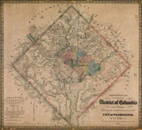

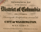


Washington, D.C. Fortifications and City Sections – 1862 Topographical Map
Washington, D.C. Fortifications and City Sections – 1862 Topographical Map
Explore the nation’s capital at the height of the Civil War through this detailed 1862 topographical map of the District of Columbia and its surrounding defenses. Created as Washington became one of the most heavily fortified cities in the world, this map documents both the city’s internal layout and the extensive ring of forts constructed to protect it from Confederate attack.
Historical Context By 1862, the survival of the Union hinged on the security of Washington, D.C. Following early Confederate successes and the proximity of enemy forces across the Potomac, federal authorities undertook an unprecedented defensive effort. More than sixty forts, batteries, and earthworks were constructed in a continuous perimeter around the capital, transforming it into a fortified stronghold.
This map reflects that moment when Washington evolved from a vulnerable political center into a military command hub. It captures the city as both a functioning capital and a defended battlefield landscape, where urban planning and military engineering converged.
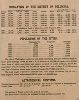
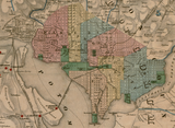
The Map’s Features This finely rendered topographical map shows the District of Columbia divided into its administrative and urban sections, overlaid with terrain contours, waterways, roads, and surrounding countryside. The defensive ring of forts is clearly identified, illustrating how high ground, river crossings, and transportation routes dictated fort placement. In the lower left corner, period statistical tables provide historical data about the District, offering rare contemporary insight into the city’s population and infrastructure during wartime. The decorative border and precise engraving reflect mid-19th-century military cartographic standards.
Historical Significance Washington’s fortifications ultimately made the city impregnable, ensuring the continuity of the federal government throughout the war. This 1862 map preserves the capital at the peak of its defensive transformation, revealing how geography, engineering, and strategy combined to safeguard the Union’s seat of power. For historians and collectors, it offers a comprehensive snapshot of Washington as both city and fortress during the Civil War’s most uncertain years.
Museum-Quality Reproduction This is a high-quality reproduction of the original 1862 map, professionally printed using museum-grade methods and materials to preserve every detail of this historic topographical and military document. Each piece is produced on archival Hahnemühle paper using the Giclée printing process, ensuring exceptional clarity, durability, and a refined finish suitable for display.
Perfect For Civil War historians and collectors; Washington, D.C. history enthusiasts; students of military engineering and urban defense; offices, libraries, and study spaces; gifts for American history collectors
Specifications
• Original Publication: 1862
• Style: Civil War–era topographical and defensive map
• Features: City sections, fortifications, terrain contours, waterways, roads, historical statistics
• Product Type: High-Quality Reproduction Print
• Dimensions (Width x Height): 26.3 x 24
Each map is printed using the finest materials and methods. Your map will be handled with white gloves from start to finish. We use the Giclée printing method on Hahnemühle paper, which produces a clear, extremely detailed, durable map perfect for proud display in your home or office.
Digital watermark does not appear on your purchased map.


