

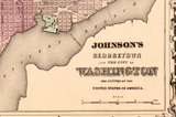


Washington City and Georgetown – Civil War–Era Ward Map
Washington City and Georgetown – Civil War–Era Ward Map
Explore Washington, D.C. and Georgetown as they were presented to the public during the Civil War with this richly detailed ward map published in 1862 as part of Johnson’s New Illustrated Family Atlas. While grounded in contemporary geography, this map also reflects an idealized vision of the capital—combining lived urban reality with aspirational illustrations of national landmarks intended to portray Washington as a complete and enduring seat of government.
Historical Context
In 1862, Washington was a city under extraordinary strain, serving simultaneously as the political heart of the Union and an active military hub surrounded by forts, hospitals, and troop concentrations. Georgetown—older than Washington itself—remained a vital commercial and residential city along the Potomac, closely tied to shipping, industry, and daily civic life. Mid-19th-century atlases like this one were prestige publications, designed not only to inform but to project confidence and permanence at a time when the nation’s future was deeply uncertain.
The Map’s Features
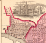
This map presents Washington City and Georgetown with color-tinted ward divisions, a clear street grid, major avenues, public squares, and the Potomac River shoreline. Georgetown is distinctly labeled and fully integrated into the capital’s layout, making the map especially compelling for those with ties to that historic neighborhood. Decorative vignette illustrations depict the Washington Monument, the U.S. Capitol, and the Smithsonian Institution—not as they physically appeared in 1862, but as they were intended to look once completed. The Washington Monument is shown according to Robert Mills’s original 1845 design, complete with its planned colonnaded base, while the Capitol appears crowned by its fully realized cast-iron dome, still under construction at the time.
Historical Significance
This map captures both the reality and the ambition of Civil War–era Washington. In 1862, the Washington Monument stood unfinished at just 152 feet, its construction halted for years, and the Capitol dome rose amid scaffolding as President Lincoln insisted work continue as a symbol of Union resolve. By depicting these structures in their completed, idealized forms, the map reflects how publishers sought to present Washington not as a city in crisis, but as the inevitable and enduring capital of the United States. For collectors and historians, it offers a revealing look at how Americans envisioned their capital during one of its most consequential moments.
Museum-Quality Reproduction
This is a high-quality reproduction of the original 1862 atlas map, professionally printed using museum-grade methods and materials to preserve every line, color wash, and decorative engraving.
Perfect For:
• Washington, D.C. and Georgetown residents past and present
• Civil War–era and urban history enthusiasts
• Collectors of historic city maps and decorative cartography
• Offices, libraries, and study spaces
• Gifts for DC and Georgetown history lovers
Specifications:
• Created / Published: 1862
• Cartographer / Publisher: Johnson & Ward
• Style: Decorative ward map with vignette illustrations
• Product Type: High-Quality Reproduction Print
Dimensions (Width x Height): 30 x 23.9
Each map is printed using the finest materials and methods. Your map will be handled with white gloves from start to finish. We use the Giclée printing method on Hahnemühle paper, which produces a clear, extremely detailed, durable map perfect for proud display in your home or office.
Digital watermark does not appear on your purchased map.


