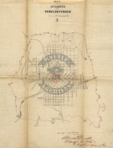

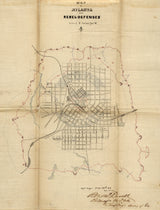


Atlanta, Georgia – 1864 Defensive Perimeter Battle Map
Atlanta, Georgia – 1864 Defensive Perimeter Battle Map
Explore the fortified heart of the Confederacy with this detailed defensive perimeter map of Atlanta, created during the final stages of the 1864 campaign. This historic battle map illustrates the ring of fortifications constructed to defend Atlanta as Union forces under Major General William T. Sherman closed in on the city during the summer of the Civil War.
Historical Context
By mid-1864, Atlanta stood as one of the Confederacy’s most critical industrial and transportation centers. Anticipating a prolonged fight, Confederate forces constructed an extensive defensive perimeter of earthworks, trenches, and artillery positions encircling the city. As Sherman’s armies maneuvered and applied constant pressure, these defenses became the final shield protecting Atlanta from capture. Despite their scale and complexity, the fortifications ultimately failed to stop the Union advance. On September 2, 1864, Atlanta fell, delivering a devastating blow to the Confederate war effort. Sherman would occupy the city briefly before departing in November to begin his March to the Sea.
The Map’s Features
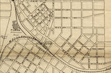
This defensive battle map clearly depicts the fortified ring surrounding Atlanta, including trench lines, redoubts, and artillery positions integrated with the city’s street grid and surrounding terrain. Rail lines, roads, and natural features are shown in relation to the defenses, offering insight into how Confederate engineers attempted to leverage geography to slow the Union advance. The map provides a rare, focused view of Atlanta as a fortified city under siege.
Historical Significance
Atlanta’s defensive perimeter represents the Confederacy’s last major effort to hold one of its most vital cities. This map preserves the physical reality of those defenses at the moment they were tested and overcome. For historians and collectors, it offers a tangible record of the siege that reshaped the course of the war and paved the way for Union operations deep into the Southern heartland.
Museum-Quality Reproduction
This is a high-quality reproduction of the original Civil War battle map, professionally printed using museum-grade methods and materials to preserve every detail of this historic military document. Each piece is produced on archival Hahnemühle paper using the Giclée printing process, ensuring exceptional clarity, durability, and a refined finish suitable for display in any setting.
Perfect For:
• Civil War historians and collectors
• Atlanta and Georgia history enthusiasts
• Military professionals and educators
• Offices, libraries, and study spaces
• Gifts commemorating Union victory and American history
Specifications:
• Battle Result: Union Victory
• Created / Published: 1864
• Style: American Civil War defensive battle map
• Product Type: High-Quality Reproduction Print
• Dimensions (Width x Height): 15.1 x 19.8
Each map is printed using the finest materials and methods. Your map will be handled with white gloves from start to finish. We use the Giclée printing method on Hahnemühle paper, which produces a clear, extremely detailed, durable map perfect for proud display in your home or office.
Digital watermark does not appear on your purchased map.


