


Los Angeles, California - 1891 Bird's Eye View Map
Los Angeles, California - 1891 Bird's Eye View Map
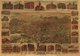
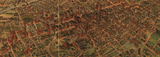
Experience Los Angeles during its first great boom with this sweeping panoramic view from 1891. Published by Elliott Publishing Company, this large-format bird's eye view captures the city at a transformative moment—population surging past 65,000, railroads connecting the region to the nation, and speculators carving the agricultural ranchos into city blocks at a frenzied pace.
The Great Southern California Land Boom
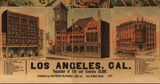
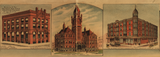
This meticulously detailed illustration showcases Los Angeles spreading dramatically across the coastal basin, with the San Gabriel Mountains forming a majestic backdrop. Every street, building, and neighborhood reveals a city in explosive growth—Victorian homes replacing adobe structures, electric streetcar lines extending into new subdivisions, and commercial blocks rising where orange groves stood just years before. The map features elegant illustrations of significant buildings and landmarks, along with an indexed guide to points of interest that documents the ambitious civic and commercial development reshaping the city.
Historical Significance
The 1891 map captures Los Angeles in the aftermath of the legendary 1880s land boom, when competing railroads slashed fares to nearly nothing and speculators platted hundreds of new towns across Southern California. Though many of those boom-time towns would fail, Los Angeles itself emerged permanently transformed—connected by rail to San Francisco and the East, attracting settlers from across the nation, and positioned to become the metropolis it would claim to be. Within two decades, oil discoveries and the completion of the Los Angeles Aqueduct would fuel even more explosive growth, but this 1891 view captures the city at the crucial moment when it first became a true American city rather than a frontier outpost.
Museum-Quality Reproduction
This is a high-quality reproduction of the original 1891 map, professionally printed using museum-grade methods and materials to preserve every detail of this historic cartographic treasure.
Perfect For:
- History enthusiasts and collectors of Americana
- California natives and Los Angeles residents
- Anyone passionate about Western expansion and California history
- Displaying alongside your military and historical collections
- Gift-giving for those who appreciate historical artifacts
Specifications:
- Original Publication: 1891
- Style: Bird's eye view perspective
- Features: Building illustrations, indexed points of interest
- Product Type: High-Quality Reproduction Print
Dimensions (Width x Height): 30 x 21.1
Each map is printed using the finest materials and methods. Your map will be handled with white gloves from start to finish. We use the Giclee printing method on Hahnemuhle paper, which produces a clear, extremely detailed, durable map that is perfect to be proudly displayed in your home or office.
Digital watermark does not appear on your purchased map.


