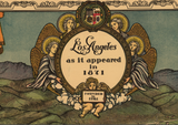


Los Angeles, California - 1871 Historical Reconstruction Map
Los Angeles, California - 1871 Historical Reconstruction Map
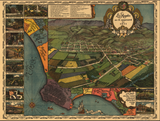
Step back to the era when Los Angeles was still a dusty pueblo of fewer than 6,000 residents with this historical bird's eye view depicting the city as it appeared in 1871. Created in 1929 by the Women's University Club of Los Angeles and approved by the Historical Society of Southern California, this carefully researched reconstruction captures the city in its final years as a sleepy frontier settlement before the transcontinental railroad would transform it into one of America's greatest metropolises.
From Spanish Pueblo to American Town
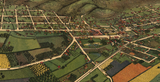
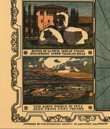
This meticulously detailed illustration showcases Los Angeles spread across the flat basin with the San Gabriel Mountains rising dramatically in the background. Every adobe structure, early Victorian building, and tree-lined street reveals a community still deeply rooted in its Spanish and Mexican heritage while gradually adopting American architectural styles. The map includes vivid color illustrations and historical notes that bring this forgotten era to life, while a special inset map shows the original Spanish ranchos that defined the region's vast agricultural landscape before subdivision and development.
Historical Significance
In 1871, Los Angeles stood at a crossroads. Just 20 years removed from American conquest during the Mexican-American War, the city retained its bilingual, bicultural character while positioning itself for explosive growth. The transcontinental railroad would arrive within a few years, triggering the land boom that would reshape Southern California forever. This historically accurate reconstruction captures that pivotal moment—the calm before the storm of development that would increase the population a hundredfold within two generations. The original Spanish rancho boundaries shown here document a way of life that would vanish within a decade, making this an invaluable record of Los Angeles' pastoral past.
Museum-Quality Reproduction
This is a high-quality reproduction of the 1929 historical map, professionally printed using museum-grade methods and materials to preserve every detail of this historic cartographic treasure.
Perfect For:
- History enthusiasts and collectors of Americana
- California natives and Los Angeles residents
- Anyone passionate about Western expansion and California history
- Displaying alongside your military and historical collections
- Gift-giving for those who appreciate historical artifacts
Specifications:
- Map Depicts: Los Angeles as it appeared in 1871
- Original Publication: 1929 (Historical Society of Southern California approved)
- Style: Bird's eye view perspective
- Features: Hand-colored illustrations, historical notes, original Spanish ranchos map
- Product Type: High-Quality Reproduction Print
Dimensions (Width x Height): 30 x 22.5
Each map is printed using the finest materials and methods. Your map will be handled with white gloves from start to finish. We use the Giclee printing method on Hahnemuhle paper, which produces a clear, extremely detailed, durable map that is perfect to be proudly displayed in your home or office.
Digital watermark does not appear on your purchased map.


