


Washington, D.C. - 1861 Bird's Eye View Map
Washington, D.C. - 1861 Bird's Eye View Map
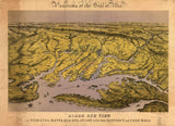
Experience the nation's capital at the outbreak of the Civil War with this detailed 1861 bird's eye view by renowned lithographer Edward Sachse. Created in the tumultuous year when Southern states seceded and war erupted at Fort Sumter, this panoramic view captures Washington as it transformed from a sleepy Southern town into a fortified military headquarters preparing for the greatest crisis in American history.
The Capital on the Brink of War
This magnificent bird's eye perspective reveals Washington, D.C. at a pivotal moment in 1861. From an elevated vantage point, the map displays the iconic landmarks that defined the capital—the unfinished Capitol dome (still under construction when war began), the White House, the Patent Office, the Treasury Building, and the Smithsonian Institution. The grid pattern of streets radiates from these central monuments, while the Potomac River curves along the city's edge, just across from Virginia which had joined the Confederacy in April 1861. The relatively modest scale of the capital is evident—a city of fewer than 75,000 residents about to be transformed by war into a massive military encampment. Within months of this view's creation, troops would pour into Washington, fortifications would ring the city, and the population would swell with soldiers, contractors, and freed slaves seeking protection behind Union lines.
Historical Significance
The Washington captured in this 1861 bird's eye view stands at the hinge of American history. When Abraham Lincoln took office in March 1861, Washington remained a Southern city in character—slavery was legal in the capital, many residents sympathized with secession, and Virginia's departure from the Union placed Confederate territory directly across the Potomac. The outbreak of war in April transformed Washington into a fortress city. Troops camped in the Capitol building itself, fortifications sprouted on every hill, and the sleepy capital became the nerve center of the Union war effort. This view preserves the last image of antebellum Washington—before the war's upheaval would permanently transform both the physical city and the federal government's role in American life. The unfinished Capitol dome visible in this view would be completed during the war, with Lincoln insisting construction continue as a symbol that the Union would endure.
Museum-Quality Reproduction
This is a high-quality reproduction of the original 1861 bird's eye view, professionally printed using museum-grade methods and materials to preserve every detail of Edward Sachse's masterwork.
Perfect For:
- Civil War enthusiasts and Washington, D.C. residents
- History collectors fascinated by America's capital city
- Students of Lincoln and the Civil War era
- Anyone passionate about American history
- Gift-giving for history buffs and government employees
Specifications:
- Original Publication: 1861
- Creator: Edward Sachse & Co., Baltimore
- Style: Bird's eye perspective view with detailed landmark illustrations
- Historical Context: Created at the outbreak of the Civil War
- Features: Unfinished Capitol dome, White House, major government buildings, Potomac River
- Product Type: High-Quality Reproduction Print
Dimensions (Width x Height): 25.4 x 17.1
Each map is printed using the finest materials and methods. Your map will be handled with white gloves from start to finish. We use the Giclee printing method on Hahnemuhle paper, which produces a clear, extremely detailed, durable map that is perfect to be proudly displayed in your home or office.
Digital watermark does not appear on your purchased map.


