


Mosul, Iraq – 2007 City Topographical Map
Mosul, Iraq – 2007 City Topographical Map
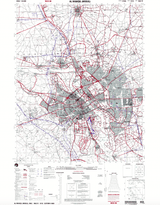
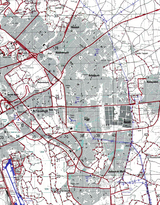
This 2007 topographical map of Mosul captures one of the most strategically significant cities of the Iraq War era. Located in northern Iraq along the Tigris River, Mosul served as a major operational hub for U.S. Army and coalition forces during the 2003–2011 conflict.
Historical Context Mosul became a focal point of insurgent activity during the Iraq War and later gained global attention when ISIS seized control of the city in 2014. Coalition and Iraqi forces fought a prolonged campaign to retake Mosul, culminating in its liberation in 2017. For many American and allied service members, Mosul represents a defining chapter of modern warfare.
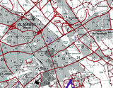
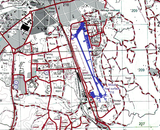
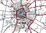
The Map’s Features This highly detailed 1:50,000-scale map shows Mosul’s dense urban grid, the Tigris River bisecting the city, major road networks, airfields, bridges, elevation contours, and surrounding terrain. Military grid references and topographical markings reflect the operational planning tools used by ground forces. The map provides a precise snapshot of Mosul’s layout during the height of coalition operations.
Historical Significance Mosul played a central role in counterinsurgency operations and later in the campaign against ISIS. This map preserves the geographic framework of one of the most consequential urban battlefields of the 21st century.
Museum-Quality Reproduction This is a high-quality reproduction of the original 2007 map, professionally printed on archival Hahnemühle paper using the Giclée printing process to preserve its fine detail, color contrast, and topographical precision for generations.
Perfect For:
• Iraq War veterans and military families
• Modern military history collectors
• Units and service members who operated in northern Iraq
• Offices, studies, and commemorative displays
• Gifts honoring service and sacrifice
Specifications:
• Created/Published: 2007
• Scale: 50,000
• Conflict: Iraq War
• Battle Result: American and Allied Nations Victory
• Product Type: High-Quality Reproduction Print
Dimensions (Width x Height): 21.9 x 28.2
Each map is printed using the finest materials and methods. Your map will be handled with white gloves from start to finish. We use the Giclée printing method on Hahnemühle paper, which produces a clear, extremely detailed, durable map perfect for proud display in your home or office.


