


Helmand Province, Afghanistan – 2003 Provincial Map
Helmand Province, Afghanistan – 2003 Provincial Map
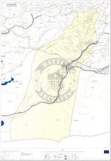
This detailed provincial map of Helmand Province captures one of the most significant regions of U.S. military operations during the war in Afghanistan. Covering the entire province with modern geographic precision, the map presents the rivers, road networks, settlements, and borders that defined daily movement and operations across Helmand during the early years of the conflict.
Historical Context
Helmand Province is the largest province in Afghanistan by land area and occupies a critical position in the country’s south-central region. Bordered by Kandahar Province to the east, Nimruz Province to the west, and Pakistan to the south, Helmand became a focal point of counterinsurgency and stabilization efforts following the U.S. invasion of Afghanistan. After the troop surge of 2009, U.S. Marines assumed primary responsibility for combat and security operations throughout the province, operating from well-known areas along the Helmand River Valley.
The Map’s Features
This provincial reference map presents Helmand with clarity and geographic detail, showing major population centers, transportation routes, rivers, terrain features, and provincial boundaries. The Helmand River dominates the map, tracing the lifeline that shaped both civilian life and military operations. Notably, the mapmaker uses the spelling “Hilmand Province,” a historically accepted alternate transliteration that appears in several Western cartographic sources.
Historical Significance
For those who served in Afghanistan, Helmand Province represents a defining chapter of modern U.S. military history. This map serves not as a battle diagram, but as a geographic anchor—a way to locate patrol areas, bases, river crossings, and districts that shaped individual deployments. It offers a powerful point-of-reference connection for veterans, military families, and historians seeking to understand where operations unfolded on the ground.
Museum-Quality Reproduction
This is a high-quality reproduction of the original provincial map, professionally printed using museum-grade methods and materials to preserve every detail of the source document.
Perfect For:
• Veterans who served in Helmand Province
• U.S. Marines and coalition forces deployed to southern Afghanistan
• Military families and remembrance displays
• Offices, studies, and personal military collections
• Gifts honoring service and deployment history
Specifications:
• Created / Published: 2003
• Style: Modern provincial geographic reference map
• Product Type: High-Quality Reproduction Print
• Dimensions (Width x Height): 22.5 x 31.1
Each map is printed using the finest materials and methods. Your map will be handled with white gloves from start to finish. We use the Giclée printing method on Hahnemühle paper, which produces a clear, extremely detailed, durable map that is perfect to be proudly displayed in your home or office.
Digital watermark does not appear on your purchased map.


